Theodore Roosevelt Bridge, Washington, D.C.: Location, Length, Height, Toll, History & Facts
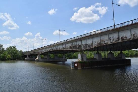
Theodore Roosevelt Bridge passes directly over the island that serves as Washington’s living memorial to the 26th president. Theodore Roosevelt Island sits in the middle of the Potomac River, covered in woodland trails, and the bridge carries Interstate 66 and US Route 50 right above its southern tip. The bridge was described as a “ribbon of steel” when its design was approved in the 1950s. It opened on June 23, 1964, linking Rosslyn in Arlington, Virginia with Washington, D.C., near the Kennedy Center. Today it carries about 95,000 vehicles a day, roughly a quarter of the city’s Potomac River crossings, and there’s no toll.
Theodore Roosevelt Bridge Key Facts
| Detail | Information |
| Other names | Teddy Roosevelt Bridge, Roosevelt Bridge, T.R. Bridge |
| Location | Potomac River, between Rosslyn (Arlington, Virginia) and Foggy Bottom/the Kennedy Center area (Washington, D.C.), crossing over Theodore Roosevelt Island |
| Coordinates | Approx. 38.8921° N, 77.0612° W |
| Highways | Interstate 66 and US Route 50 |
| Owner/maintainer | District Department of Transportation (DDOT) |
| Bridge type | Continuous steel girder bridge (haunched girders) |
| Design approved | December 1955, by the U.S. Commission of Fine Arts |
| Name made official | June 4, 1958 (signed by President Eisenhower) |
| Construction began | 1960 |
| Opened | June 23, 1964 |
| Total length | About 3,200 ft, including the Potomac River and Little River sections |
| Main river section | About 1,762 ft long, with 8 spans; longest span about 222 ft |
| Deck width | About 98 ft |
| Lanes | 7 (including one reversible lane with a movable “zipper” barrier) |
| Daily traffic | About 95,000 vehicles (about 32.6 million a year) |
| Rehabilitation | Began May 2025; about $128 million; expected completion spring 2028 |
| Toll | None |
| Pedestrians and cyclists | North-side sidewalk (being widened to about 10 ft) |
| Time zone | Eastern Time: UTC−5 (EST), UTC−4 (EDT, second Sunday in March to first Sunday in November) |
Over the Potomac and Roosevelt Island
The Theodore Roosevelt Bridge crosses the Potomac in two sections. One section spans the main river between Washington and Theodore Roosevelt Island. The other crosses the narrow Little River channel between the island and the Virginia shore. Together, they stretch about 3,200 feet.
On the D.C. side, the bridge lands just south of the Kennedy Center, where I-66 continues north along the Potomac River Freeway and US 50 heads east onto Constitution Avenue toward the National Mall. On the Virginia side, it lands near Rosslyn, connecting with I-66 westbound, US 50 (Arlington Boulevard) and the George Washington Memorial Parkway.
Although the bridge crosses over Theodore Roosevelt Island, there’s no access to the island from the bridge itself. Visitors reach the island by a footbridge from a parking area on the George Washington Memorial Parkway.
A “Ribbon of Steel”
The bridge’s simple, low profile was chosen so it wouldn’t overwhelm the views along the Potomac near Washington’s monuments.
- It’s a continuous steel girder bridge, with graceful haunched girders that are deeper over the piers and thinner in the middle of each span.
- The main river section is about 1,762 feet long, with eight spans. The longest is about 222 feet.
- The deck is about 98 feet wide.
- It normally carries seven lanes, including one reversible lane. A zipper barrier moves that lane back and forth to add capacity in whichever direction is busiest.
The U.S. Commission of Fine Arts approved the steel design in December 1955, praising it as a clean “ribbon of steel” across the river. Once the bridge opened in 1964, large ships could no longer travel upstream past it, which is one reason the old drawbridge on the nearby Arlington Memorial Bridge never needed to open again.
No Toll
The Theodore Roosevelt Bridge is free for all drivers, cyclists and pedestrians. Tips for using it:
- The bridge is one of the busiest commuter routes into Washington, so expect heavy traffic during morning and evening rush hours.
- Lane configurations have been changing during the rehabilitation project. Check DDOT’s Theodore Roosevelt Bridge project website for current traffic patterns, ramp closures and detours.
- Pedestrians and cyclists can use the sidewalk on the north side, which is being widened as part of the current project.
- The bridge has wide views of the Potomac, the Kennedy Center, the Washington Monument and the Georgetown waterfront.
Planning and Building the Bridge
Plans for a new Potomac River crossing between Rosslyn and downtown Washington began in the early 1950s, as traffic between Northern Virginia and the capital grew rapidly. The proposed route crossed Theodore Roosevelt Island, which had been dedicated as a memorial to the president, so planners worked carefully on a design and alignment that would respect the island’s natural setting.
The Commission of Fine Arts approved the steel design in 1955. On June 4, 1958, President Dwight D. Eisenhower signed legislation officially naming it the Theodore Roosevelt Bridge. Construction began in 1960, and the bridge opened to traffic on June 23, 1964. It later became part of Interstate 66, giving drivers a direct freeway link between Northern Virginia and downtown Washington.
The Rehabilitation Project
After more than 60 years of service, the bridge is getting a major update. DDOT began a rehabilitation project in May 2025, at a cost of about $128 million, with completion expected in spring 2028. The work includes:
- Replacing the bridge deck and making structural steel repairs.
- Repainting all the structural steel.
- Widening the north sidewalk from about 5 feet to about 10 feet, creating a better path for pedestrians and cyclists.
- Installing upgraded traffic barriers and pedestrian railings.
- Replacing all signs and sign structures.
The project is designed to extend the bridge’s life by 20 to 30 years. The reversible zipper lane will return once deck replacement is complete.
Theodore Roosevelt Island
The island beneath the bridge is one of Washington’s hidden treasures. The 88-acre island, managed by the National Park Service, was turned into a memorial to Theodore Roosevelt, a great champion of conservation. Visitors can:
- Walk about 2.5 miles of trails through woods and wetlands.
- Visit the memorial plaza, with a 17-foot bronze statue of Roosevelt and granite tablets carved with his quotes.
- Spot birds, turtles and other wildlife along the shoreline.
- Rent kayaks and paddleboards nearby to explore the Potomac around the island.
Things to Do Nearby
- The Kennedy Center, at the D.C. end of the bridge, hosts performances and has a rooftop terrace with river views.
- The Georgetown Waterfront Park, just upstream, has fountains, lawns and riverfront dining.
- The Mount Vernon Trail runs along the Virginia shore past the bridge, popular with cyclists and runners.
- The Lincoln Memorial and the National Mall are a short walk from the bridge’s D.C. end.
FAQs
Q1. Is there a toll on the Theodore Roosevelt Bridge?
A. No. The Theodore Roosevelt Bridge is free to cross.
Q2. How long is the Theodore Roosevelt Bridge?
A. The bridge is about 3,200 feet long in total, including a main river section of about 1,762 feet.
Q3. When did the Theodore Roosevelt Bridge open?
A. It opened to traffic on June 23, 1964.
Q4. Which highways cross the Theodore Roosevelt Bridge?
A. Interstate 66 and US Route 50 cross the bridge.
Q5. Can you get to Theodore Roosevelt Island from the bridge?
A. No. The island is reached by a footbridge from a parking area on the George Washington Memorial Parkway in Virginia.
Q6. Can you walk across the Theodore Roosevelt Bridge?
A. Yes. Pedestrians and cyclists can use the sidewalk on the north side, which is being widened.
Q7. Is the Theodore Roosevelt Bridge being renovated?
A. Yes. A rehabilitation project began in May 2025 and is expected to be completed in spring 2028.
Q8. What does the Theodore Roosevelt Bridge connect?
A. It connects Rosslyn in Arlington, Virginia with Washington, D.C., near the Kennedy Center.
Q9. How many lanes does the Theodore Roosevelt Bridge have?
A. It normally has seven lanes, including one reversible lane that changes direction with a movable barrier.
Q10. Why is it named after Theodore Roosevelt?
A. It honors President Theodore Roosevelt and crosses over Theodore Roosevelt Island, a memorial to him in the Potomac River.







Post Comment