Dumbarton Bridge, Fremont, CA: Location, Length, Height, Toll, History & Facts
Dumbarton Bridge is the southernmost and shortest of the bridges across San Francisco Bay, but it was the first. Its 1927 predecessor was the first vehicle bridge ever built over the bay, a decade before the Golden Gate and Bay bridges opened. Today’s bridge opened in October 1982 and carries State Route 84 about 1.6 miles across the bay, between Fremont and Newark in the East Bay and Menlo Park and East Palo Alto on the Peninsula. It was also the first bay crossing with a full bike lane, and walkers and cyclists still share a separated path along its south side. Drivers pay only heading west: $8.50 in 2026.
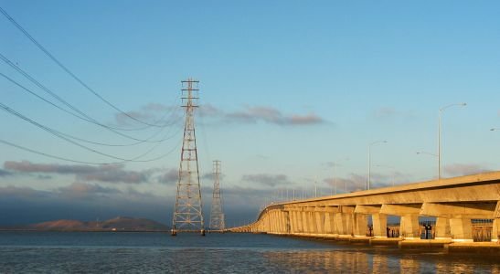
Dumbarton Bridge Key Facts
| Detail | Information |
| Location | Southern San Francisco Bay, between Fremont/Newark (Alameda County) and Menlo Park/East Palo Alto (San Mateo County), California |
| Coordinates | Approx. 37.5050° N, 122.1150° W |
| Highway | State Route 84 |
| Operators | Caltrans and the Bay Area Toll Authority |
| Bridge type | High-level girder bridge with concrete approaches |
| Original bridge opened | January 1927 (first vehicle bridge across San Francisco Bay) |
| Original bridge cost | About $2.25 million |
| Current bridge opened | October 1982 |
| Current bridge cost | About $70 million |
| Total length | About 8,600 ft (1.63 miles), the shortest of the bay’s toll bridges |
| Main span | 340 ft (104 m) |
| Vertical clearance | 85 ft (26 m) |
| Lanes | 6 (3 each way, separated by a concrete barrier) |
| Bike and pedestrian path | Separated path on the south side |
| Daily traffic | About 70,000–81,000 vehicles |
| Annual toll-paid vehicles | About 9.6 million (FY 2022–23) |
| Toll direction | Westbound only |
| Car toll (2026) | $8.50 |
| Carpool toll | $4.25 (FasTrak only, weekday rush hours) |
| Payment | All-electronic (no cash) |
| Time zone | Pacific Time: UTC−8 (PST), UTC−7 (PDT, second Sunday in March to first Sunday in November) |
Across the South Bay
The Dumbarton Bridge crosses the narrow southern arm of San Francisco Bay. On the east side, it begins near Fremont and Newark, connecting with Interstate 880 by way of State Route 84. On the west side, it lands near Menlo Park and East Palo Alto, connecting with US 101 by way of the Bayfront Expressway.
The bridge is a key link for commuters traveling between East Bay neighborhoods and the tech campuses and offices of Silicon Valley. It’s named after Dumbarton Point on the east shore, which in turn took its name from Dumbarton in Scotland. The surrounding landscape of marshes, mudflats and colorful salt ponds is home to huge numbers of shorebirds and waterfowl.
A Compact, High-Level Bridge
The current Dumbarton Bridge was built as a high-level crossing, so it never needs to open for boats.
- The total length is about 8,600 feet, roughly 1.63 miles.
- Its main span over the shipping channel is 340 feet.
- The main span gives boats 85 feet of vertical clearance.
- The bridge carries six lanes of traffic, three in each direction, separated by a concrete barrier.
- A separated bike and pedestrian path runs along its south side.
The bridge was built about 90 feet north of the original 1927 span. When it opened in October 1982, it carried four lanes. In 1989, after the Loma Prieta earthquake temporarily closed the Bay Bridge, the Dumbarton was re-striped to carry six lanes, its configuration today.
Paying the Toll
Tolls are collected only from westbound drivers, heading from the East Bay toward the Peninsula. Eastbound trips are free. The bridge is fully cashless.
| Payment method | Car toll (2026) |
| FasTrak | $8.50 |
| License plate account, one-time payment or invoice | $8.50 |
| Carpool (3+ people, FasTrak Flex) | $4.25 |
Tips for drivers:
- The carpool discount applies on weekdays from 5 to 10 a.m. and 3 to 7 p.m. for vehicles with three or more people using a FasTrak Flex tag set to “3+.”
- Tolls on the Bay Area’s state-owned bridges are scheduled to rise each year through 2030.
- The approaches on both sides can back up during rush hour, especially heading west in the morning.
Walking and Biking the Dumbarton
The Dumbarton Bridge offers one of the best ways to experience the South Bay on foot or by bike:
- The path runs along the south side of the bridge, separated from traffic by a barrier.
- It connects with the San Francisco Bay Trail on both shores.
- From the top, there are wide views of the bay, the salt ponds, the Santa Cruz Mountains and the East Bay hills.
- The route is often windy, especially in the afternoon, so plan for a steady headwind in one direction.
- Bring water, since there are no services on the bridge itself.
The First Bridge Across the Bay
In the early 1920s, a private company set out to build the first road bridge across San Francisco Bay at its narrowest southern point. The original Dumbarton Bridge opened in January 1927, at a cost of about $2.25 million. At the time, it was the first vehicle bridge to span the bay, and newspapers celebrated how much time it saved. It cut about 15 miles off the drive between the East Bay and Palo Alto, a welcome shortcut for Stanford football fans, among others.
The original bridge was a two-lane crossing with a lift span that could rise to let boats through. The first drivers paid a toll of about 75 cents. In 1951, the State of California bought the bridge, along with the San Mateo Bridge. The old Dumbarton even had a moment of movie fame, appearing in a memorable scene in the 1971 film Harold and Maude.
Building the 1982 Bridge
By the 1970s, the narrow two-lane bridge and its lift span could no longer handle the region’s growth. The state built a new, higher, wider bridge just north of the old one, which opened in October 1982 at a cost of about $70 million. Its 85-foot clearance meant there was no need for a lift span, so traffic would never have to stop for boats.
After the new bridge opened, the old bridge’s center lift span was removed in 1984. Parts of the original approaches were later turned into fishing piers.
Improvements Over the Years
The Dumbarton Bridge has been updated several times:
- 1989: Re-striped from four lanes to six.
- Regional Measure 1: The Bayfront Expressway, the western approach from US 101, was widened from four to six lanes.
- Seismic retrofit: The bridge was strengthened to better withstand earthquakes.
- Bike and pedestrian improvements: Better connections to the Bay Trail on both shores.
Things to Do Nearby
- Don Edwards San Francisco Bay National Wildlife Refuge, near the bridge’s east end, has trails, a visitor center and excellent birdwatching.
- Coyote Hills Regional Park in Fremont offers trails through hills and marshes, plus Native American history exhibits.
- Bedwell Bayfront Park in Menlo Park has bayside trails and views of the bridge.
- The Dumbarton Rail Bridge, just south, is a historic railroad swing bridge across the bay.
- Downtown Palo Alto and Stanford University are a short drive from the bridge’s west end.
FAQs
Q1. How much is the Dumbarton Bridge toll in 2026?
A. The toll is $8.50 for cars, collected only on westbound trips. Carpools pay $4.25 during weekday rush hours.
Q2. Is the Dumbarton Bridge toll charged both ways?
A. No. Tolls are collected only westbound, heading toward the Peninsula.
Q3. Does the Dumbarton Bridge accept cash?
A. No. Tolls are fully electronic, by FasTrak, license plate account, one-time payment or invoice.
Q4. How long is the Dumbarton Bridge?
A. It’s about 8,600 feet long, roughly 1.63 miles.
Q5. How high is the Dumbarton Bridge?
A. Its main span gives boats 85 feet of vertical clearance.
Q6. When did the current Dumbarton Bridge open?
A. It opened in October 1982. The original bridge opened in January 1927.
Q7. Was the Dumbarton Bridge the first bridge across San Francisco Bay?
A. Yes. The original 1927 Dumbarton Bridge was the first vehicle bridge across the bay.
Q8. Can you walk or bike across the Dumbarton Bridge?
A. Yes. A separated bike and pedestrian path runs along the south side of the bridge.
Q9. What does the Dumbarton Bridge connect?
A. It connects Fremont and Newark in the East Bay with Menlo Park and East Palo Alto on the Peninsula, carrying State Route 84.
Q10. Why is it called the Dumbarton Bridge?
A. It’s named after Dumbarton Point on the east shore, which took its name from Dumbarton in Scotland.






Post Comment