Sunshine Bridge, St. James, LA: Location, Length, Height, Toll, History & Facts
Sunshine Bridge takes its name from a song. When the steel cantilever bridge over the Mississippi River was built in the early 1960s, Louisiana’s governor was Jimmie Davis, the singer behind “You Are My Sunshine.” Davis turned down an offer to put his own name on the bridge, so it was named after his famous hit instead. The bridge rises 170 feet above the Mississippi in St. James Parish, about halfway between Baton Rouge and New Orleans. It carries Louisiana Highway 70 from Donaldsonville on the west bank to Sorrento and Gonzales on the east bank. When it opened in 1964, it was the only bridge across the river between those two cities. The original 50-cent toll ended in 2001, so it’s free to cross.
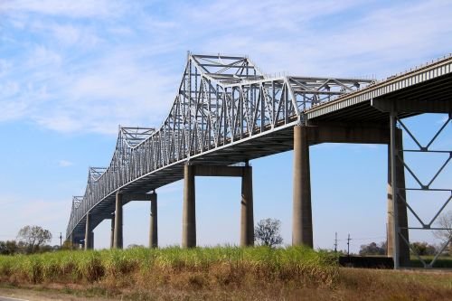
Sunshine Bridge Key Facts
| Detail | Information |
| Location | Mississippi River in St. James Parish, Louisiana, linking Donaldsonville (west bank) with Sorrento and Gonzales (east bank) in Ascension Parish |
| Coordinates | Approx. 30.0960° N, 90.9120° W |
| Highway | Louisiana Highway 70 (LA 70) |
| Owner | Louisiana Department of Transportation and Development (LaDOTD) |
| Bridge type | Steel cantilever truss bridge |
| Completed | 1963 |
| Opened | August 1964 |
| Total length | About 8,236 ft (2,510 m), roughly 1.6 miles |
| Main span | About 825 ft (251 m) |
| Clearance above the river | About 170 ft (52 m) |
| Lanes | 4 |
| Named for | “You Are My Sunshine,” the song by Governor Jimmie Davis |
| Original toll | 50 cents, collected westbound from 1964 to August 15, 2001 |
| Toll today | None |
| Distinction | Only Mississippi River bridge between New Orleans and Baton Rouge when it opened |
| Nearest bridges | Horace Wilkinson Bridge (upriver, Baton Rouge); Veterans Memorial Bridge (downriver, Gramercy) |
| Time zone | Central Time: UTC−6 (CST), UTC−5 (CDT, second Sunday in March to first Sunday in November) |
Halfway Between Baton Rouge and New Orleans
The Sunshine Bridge crosses the Mississippi River in St. James Parish, in the heart of Louisiana’s River Parishes. Its west end lands near Donaldsonville, a historic river town that briefly served as Louisiana’s state capital in the 1830s. Its east end connects with LA 70 toward Sorrento and Gonzales, where it meets Interstate 10 and Airline Highway (US 61).
LA 70 continues west from the bridge toward Pierre Part, Belle Rose and eventually Morgan City and US 90. That makes the Sunshine Bridge a key link between I-10 and the bayou country and Gulf Coast communities of south-central Louisiana.
A Tall Steel Cantilever
The Sunshine Bridge is a steel cantilever truss, with arms that reach out from its main piers and meet high above the river channel.
- The total length is about 8,236 feet, roughly 1.6 miles, including long approach spans on both sides.
- The main span over the shipping channel is about 825 feet.
- The deck rises about 170 feet above the water, giving plenty of room for the ocean-going ships and towboats that use this busy stretch of the Mississippi.
- The bridge carries four lanes of traffic.
From the top of the bridge, drivers can see miles of the winding Mississippi, the sugarcane fields of the River Parishes, and the riverside industries and towns along both banks.
Free to Cross Since 2001
There’s no toll on the Sunshine Bridge today. From its opening in 1964 until August 15, 2001, drivers heading to the west bank paid a 50-cent toll. The Louisiana Legislature ended the toll with a bill authored by State Representative Roy Quezaire of Donaldsonville, whose district included the bridge.
Tips for drivers:
- The bridge is steep, so trucks and heavy vehicles may slow down on the climb.
- LA 70 on the east side connects directly with I-10, making the bridge a handy shortcut between I-10 and the west bank.
- A widening project on LA 70 between the bridge and Sorrento has been underway, so watch for construction zones and updated lane patterns.
- Check LaDOTD traffic updates before crossing, especially during bad weather.
Building the Bridge
In the early 1960s, there was no bridge across the Mississippi between New Orleans and Baton Rouge, a distance of about 80 miles. People living in the River Parishes relied on ferries to cross. Governor Jimmie Davis’s administration pushed for a new bridge to connect the two banks in Ascension and St. James parishes.
The bridge was completed in 1963 and opened to traffic in August 1964. At first, connecting roads on one side weren’t finished, and it took several years of funding and construction to fully link the bridge with LA 70 and the surrounding highways. Once those roads were complete, the bridge became a vital connection for commuters, farmers and industries on both sides of the river.
Who Was Jimmie Davis?
Jimmie Davis was one of the most colorful figures in Louisiana history. A singer and songwriter from northern Louisiana, he became famous in 1940 with “You Are My Sunshine,” which went on to become one of the most widely recorded songs in American music. It’s also one of Louisiana’s two official state songs.
Davis served two terms as Louisiana’s 47th governor, from 1944 to 1948 and again from 1960 to 1964. He often campaigned with his guitar in hand, and at his second inauguration he famously rode his horse, also named Sunshine, into the state capitol. He was inducted into the Country Music Hall of Fame in 1972 and lived to the age of 101.
When the new bridge was being completed, Davis declined to have it named after himself, so it became the Sunshine Bridge, a lasting nod to his most beloved song.
Things to Do Nearby
- Historic Donaldsonville, near the bridge’s west end, has a historic downtown, local restaurants and the River Road African American Museum.
- The Great River Road runs along both banks of the Mississippi, past historic homes, sugarcane fields and small river towns.
- Gonzales, east of the bridge, calls itself the “Jambalaya Capital of the World” and hosts the annual Jambalaya Festival.
- The Mississippi River levee offers views of the bridge and passing ships from both banks.
- Baton Rouge and New Orleans are each about an hour’s drive away.
FAQs
Q1. Is there a toll on the Sunshine Bridge?
A. No. The 50-cent toll ended on August 15, 2001, and the bridge is now free to cross.
Q2. Why is it called the Sunshine Bridge?
A. It’s named for “You Are My Sunshine,” the famous song by Louisiana Governor Jimmie Davis, who declined to have the bridge named after himself.
Q3. How long is the Sunshine Bridge?
A. It’s about 8,236 feet long, roughly 1.6 miles, with a main span of about 825 feet.
Q4. How high is the Sunshine Bridge?
A. The deck rises about 170 feet above the Mississippi River.
Q5. When was the Sunshine Bridge built?
A. It was completed in 1963 and opened to traffic in August 1964.
Q6. Where is the Sunshine Bridge?
A. It’s in St. James Parish, Louisiana, about halfway between Baton Rouge and New Orleans.
Q7. What does the Sunshine Bridge connect?
A. It connects Donaldsonville on the west bank with Sorrento and Gonzales on the east bank, carrying LA 70.
Q8. What type of bridge is the Sunshine Bridge?
A. It’s a steel cantilever truss bridge.
Q9. Was the Sunshine Bridge the first bridge between Baton Rouge and New Orleans?
A. Yes. When it opened in 1964, it was the only Mississippi River bridge between the two cities.
Q10. How many lanes does the Sunshine Bridge have?
A. It has four lanes of traffic.







Post Comment