Sunshine Skyway Bridge, Tampa, FL: Location, Length, Height, Toll, History & Facts
Sunshine Skyway Bridge cables are painted a bright yellow, and on a clear day you can see them from miles out in Tampa Bay, rising above the water like the sails of a ship. The bridge carries I-275 about 4.1 miles across the mouth of Tampa Bay, linking St. Petersburg in Pinellas County with Terra Ceia and Palmetto in Manatee County, and serves as the main gateway between the Tampa Bay area and southwest Florida. The current bridge opened in 1987 and is officially named the Bob Graham Sunshine Skyway Bridge. With SunPass, the crossing costs $1.16.
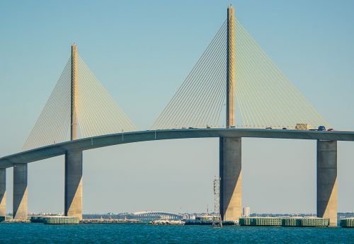
Sunshine Skyway Bridge Overview
| Detail | Information |
| Official name | Bob Graham Sunshine Skyway Bridge |
| Location | Mouth of Tampa Bay, between St. Petersburg (Pinellas County) and Terra Ceia/Palmetto (Manatee County), Florida, USA |
| Coordinates | Approx. 27.6203° N, 82.6554° W |
| Highway | I-275 / US 19 |
| Bridge type | Cable-stayed bridge (main span), with concrete approach spans |
| Designers | Figg and Muller Engineers |
| Operator | Florida Department of Transportation (FDOT) |
| Original bridge opened | September 1954 |
| Current bridge opened | April 1987 |
| Total length | About 21,877 ft (4.14 miles / 6.7 km) |
| Main span | 1,200 ft (366 m) |
| Tower height | About 430 ft (131 m) above the water |
| Clearance at channel | About 180 ft (55 m) |
| Cable color | Yellow |
| Ship protection | 36 concrete islands (“dolphins”) around the main piers |
| Traffic lanes | 4 (2 in each direction) |
| Average daily traffic | About 65,000 vehicles |
| Toll, 2-axle vehicle (SunPass) | About $1.16 |
| Toll, 2-axle vehicle (toll-by-plate) | $1.75 |
| Other accepted transponders | E-PASS, E-ZPass, Peach Pass and other compatible tags |
| Cash tolls | Not accepted (cashless since April 12, 2026) |
| Walking/cycling | Not permitted, except during special events |
| Nearby park | Skyway Fishing Pier State Park (built from the original bridge’s approaches) |
| Time zone | Eastern Time: UTC−5 (EST), UTC−4 (EDT, second Sunday in March to first Sunday in November) |
Where It Crosses the Bay
The Skyway spans the widest part of lower Tampa Bay, right where it opens into the Gulf of Mexico. The north end sits at the southern tip of St. Petersburg, near Maximo Park and Fort De Soto. The south end reaches land at Terra Ceia in Manatee County, a short drive from Palmetto, Bradenton and the road south to Sarasota.
The bridge sits over the main shipping channel into Port Tampa Bay, one of Florida’s busiest ports. Every tanker, cargo ship and cruise liner heading to Tampa passes beneath the main span. For drivers, the Skyway is part of I-275, which links St. Petersburg with I-75 south of the bay. It’s the most direct route between Pinellas County and the Gulf Coast cities to the south.
Length, Height and the Yellow Cables
The full crossing is about 4.14 miles long, most of it on low concrete approach spans that stretch across the shallow bay. The deck climbs gradually toward the center, reaching about 180 feet above the water at the shipping channel. That’s 30 feet more clearance than the original 1954 bridge had.
At the heart of the bridge is its 1,200-foot cable-stayed main span. Two concrete towers rise about 430 feet above the bay. A single row of steel cables fans out from each tower down to the center of the deck, instead of along its edges like most cable-stayed bridges. From a car, the cables seem to rise straight up out of the median. The yellow color was chosen to make the bridge stand out against the blue water and sky, and it’s become a symbol of the Tampa Bay area.
Around the main piers, 36 concrete islands called dolphins protect the bridge from ships that might drift off course. Each one is built to absorb a heavy impact and keep vessels away from the towers.
The Toll in 2026
The Skyway went fully cashless on April 12, 2026. Drivers now pay electronically or receive a bill by mail.
| Payment method | 2-axle vehicle toll |
| SunPass or compatible transponder | About $1.16 |
| Toll-by-plate (billed by mail) | $1.75 |
- SunPass saves about a third off the toll-by-plate rate. E-PASS, E-ZPass, Peach Pass and other compatible transponders work too.
- Rental cars without a transponder are billed through toll-by-plate, and rental companies often add their own service fees. Check your rental agreement’s toll program before crossing.
- Toll revenue brings in more than $28 million a year, which goes toward maintaining and protecting the bridge.
- At $1.75, the Skyway toll is the same amount charged when the first bridge opened in 1954. Rates have gone up and down in between, but they’ve landed back where they started.
From the First Skyway to Today’s Bridge
Before the 1950s, the only way across the mouth of Tampa Bay was by ferry. The first Sunshine Skyway opened in September 1954 as a two-lane steel cantilever bridge. It shortened the trip between St. Petersburg and Bradenton considerably, and visitors came just to drive across it. A second parallel span opened in 1971 so that each bridge could carry traffic in one direction.
In 1980, a freighter struck the southbound span during a sudden storm, causing a deadly accident and a partial collapse. The state decided to build a completely new bridge, designed to handle modern shipping and with much stronger protection around its piers. Figg and Muller Engineers designed the new crossing, which used a cable-stayed design with a wider channel and higher clearance. It opened in April 1987.
In 2005, the bridge was renamed for Bob Graham, the former Florida governor and U.S. senator who pushed for its construction.
Skyway Fishing Pier State Park
Instead of demolishing the whole original bridge, Florida turned its approach spans into fishing piers that stretch out into the bay on either side of the new bridge. Together, they became Skyway Fishing Pier State Park, which opened in 1994 and gives anglers access to deep water without a boat.
- The piers are a favorite spot for catching snook, grouper, mackerel, tarpon and other Gulf species.
- They’re also among the best places to photograph the new bridge up close, especially at sunrise and sunset.
- The south pier has been partly closed since October 2025 after inspections found storm damage from Hurricane Milton. In March 2026, the state announced that the south pier will be replaced with a new structure and the north pier will be renovated to extend its life by about 20 years.
Seeing the Skyway
Since the bridge has no walkway, the best views are from shore and water:
- The rest areas at both ends of the bridge have parking, picnic spots and good views of the main span.
- Fort De Soto Park, on the southern tip of Pinellas County, has beaches and trails with the bridge on the horizon.
- The fishing piers let you walk right up close to the towers.
- Boat tours and sunset cruises from St. Petersburg regularly pass under the main span.
- At night, the towers and cables are lit and can be seen for miles across the bay.
Details That Make It Stand Out
- The bridge is often called Florida’s flagship bridge and appears on the state’s tourism materials.
- Its single row of central cables was unusual in the United States when it was built and influenced later cable-stayed bridges.
- A running race held on the bridge each year gives thousands of people a rare chance to cross it on foot.
- Strong crosswinds sometimes lead FDOT to restrict high-profile vehicles like RVs and trucks, so check the advisories before crossing in heavy weather.
- The bridge is so high above the flat bay that drivers at the top can see across the water to the Gulf of Mexico on clear days.
FAQs
Q1. How much is the Sunshine Skyway Bridge toll in 2026?
A two-axle vehicle pays about $1.16 with SunPass or $1.75 by toll-by-plate.
Q2. Does the Sunshine Skyway Bridge accept cash?
No. The bridge went cashless on April 12, 2026, so drivers pay with SunPass or a compatible transponder, or are billed by mail.
Q3. How long is the Sunshine Skyway Bridge?
The full crossing is about 4.14 miles, and the cable-stayed main span is 1,200 feet.
Q4. How tall is the Sunshine Skyway Bridge?
The towers rise about 430 feet above the water, and the deck clears the shipping channel by about 180 feet.
Q5. When was the Sunshine Skyway Bridge built?
The current bridge opened in April 1987. The original Skyway opened in September 1954.
Q6. Who designed the Sunshine Skyway Bridge?
The current bridge was designed by Figg and Muller Engineers.
Q7. Why are the Sunshine Skyway cables yellow?
They were painted yellow to stand out against the water and sky, and the color has become the bridge’s signature look.
Q8. Can you walk across the Sunshine Skyway Bridge?
No, not on a normal day. Pedestrians can cross only during special events such as the annual run.
Q9. What cities does the Sunshine Skyway Bridge connect?
It connects St. Petersburg in Pinellas County with Terra Ceia and Palmetto in Manatee County.
Q10. Is the Skyway Fishing Pier open?
The north pier is open for fishing. The south pier is partly closed while the state plans a full replacement.








Post Comment