Bayonne Bridge, Bayonne, NJ: Location, Length, Height, Toll, History & Facts
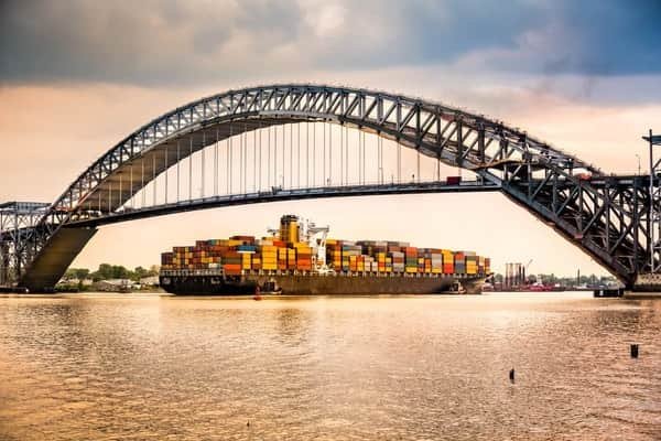
Bayonne Bridge got a lift in its late 80s. Between 2013 and 2019, the Port Authority built a brand-new roadway 64 feet higher inside the bridge’s original 1931 steel arch, keeping traffic moving the whole time. That raised the clearance over the Kill Van Kull from 151 to 215 feet, so the world’s largest container ships could reach the ports of New York and New Jersey. The arch itself, designed by Othmar Ammann and Cass Gilbert, spans 1,675 feet. When the bridge opened on November 15, 1931, that made it the longest steel arch bridge in the world. It links Bayonne, New Jersey with Staten Island, New York, and drivers pay only when heading into Staten Island.
Bayonne Bridge Key Facts
| Detail | Information |
| Location | Kill Van Kull, between Bayonne, New Jersey and Port Richmond/Elm Park, Staten Island, New York |
| Coordinates | Approx. 40.6419° N, 74.1422° W |
| Highway | Route 440 (NJ 440 / NY 440) |
| Operator | Port Authority of New York and New Jersey |
| Bridge type | Steel arch bridge (parabolic arch made of 40 straight segments) |
| Designers | Othmar H. Ammann (engineer) and Cass Gilbert (architect) |
| Opened | November 15, 1931 |
| Raise the Roadway project | 2013–2019, about $1.7 billion |
| Official reopening ceremony | June 14, 2019 |
| Arch span | 1,675 ft (511 m) |
| Total bridge length (after rebuilding) | 7,160 ft (2,182 m) |
| Width | 99.5 ft (30 m) |
| Clearance at midspan | 215 ft (66 m), up from 151 ft |
| Arch height | Lower chord about 266 ft; upper chord about 325 ft above the water |
| Lanes | 4 (2 in each direction) with shoulders |
| Walkway | Pedestrian and bicycle path on the east side (opened May 24, 2019) |
| World ranking | Longest steel arch in the world from 1931 to 1977; now about the fifth longest |
| Toll direction | Southbound only (into Staten Island) |
| Car toll: E-ZPass peak | $16.79 |
| Car toll: E-ZPass off-peak | $14.79 |
| Car toll: E-ZPass Mid-Tier | $19.55 |
| Car toll: Tolls by Mail | $23.30 |
| Staten Island Bridges Plan | $8.40 per trip with 3+ qualifying Staten Island-bound trips per month |
| Payment | Cashless (no cash accepted) |
| Time zone | Eastern Time: UTC−5 (EST), UTC−4 (EDT, second Sunday in March to first Sunday in November) |
Across the Kill Van Kull
The Kill Van Kull is a narrow tidal strait between the southern tip of Bayonne and the north shore of Staten Island. It’s one of the busiest shipping channels on the East Coast, the main route for container ships heading to Port Newark and the Elizabeth Marine Terminal, among the largest container ports in North America.
On the New Jersey side, the bridge rises from Bayonne and connects with Route 440 and the rest of Hudson County. On the Staten Island side, it lands between Port Richmond and Elm Park and continues as NY 440 toward the Staten Island Expressway. The Bayonne is one of three road bridges linking New Jersey with Staten Island. The other two are the Goethals Bridge and the Outerbridge Crossing.
The Great Steel Arch
The Bayonne Bridge’s arch is its signature. Although it looks like a smooth curve, it’s actually made up of 40 straight steel segments forming a parabola. Ammann modeled the design partly on the Hell Gate Bridge in New York, created by his mentor Gustav Lindenthal.
- The arch spans 1,675 feet across the Kill Van Kull with no piers in the water.
- The lower curve of the arch rises about 266 feet above the water, and the upper curve about 325 feet.
- The bridge is 7,160 feet long in total, including its approach viaducts.
- The deck is 99.5 feet wide.
For 46 years, it held the record as the world’s longest steel arch, until the New River Gorge Bridge in West Virginia opened in 1977.
Raising the Roadway
By the 2000s, a new generation of giant container ships, known as New Panamax ships after the expanded Panama Canal, were too tall to pass under the original 151-foot deck. The Port Authority looked at replacing the bridge with a new cable-stayed bridge or a tunnel. It chose a faster and less costly solution: build a new, higher roadway inside the existing arch.
Work began in 2013. Crews built a new deck 64 feet above the old one while traffic continued to flow below. The first new lanes opened in February 2017, and the navigational clearance of 215 feet was reached on June 8, 2017. The old lower deck was removed, the second new roadway opened in February 2019, and the new walkway followed in May 2019. An official reopening ceremony was held on June 14, 2019.
The rebuilt bridge has wider lanes, shoulders for disabled vehicles, a median barrier and new approach roads, while keeping the famous arch intact.
Tolls and Savings
Tolls are collected only southbound, from drivers heading into Staten Island. The bridge is fully cashless.
| Payment method | Car toll |
| E-ZPass peak | $16.79 |
| E-ZPass off-peak | $14.79 |
| E-ZPass Mid-Tier (tag not read) | $19.55 |
| Tolls by Mail | $23.30 |
| Staten Island Bridges Plan (NY/NJ E-ZPass) | $8.40 per trip |
Tips for drivers:
- Peak hours are 6 to 10 a.m. and 4 to 8 p.m. on weekdays, and 11 a.m. to 9 p.m. on weekends.
- The Staten Island Bridges Plan gives NY and NJ E-ZPass customers an $8.40 rate at the Bayonne, Goethals and Outerbridge crossings. It requires at least three Staten Island-bound trips in a calendar month.
- Mount your E-ZPass tag properly to avoid the Mid-Tier rate.
- The Port Authority plans to phase out the off-peak discount between 2027 and 2030.
- Pedestrians and cyclists cross for free.
Walking and Biking the Bridge
The new walkway on the east side of the bridge offers some of the most striking views in the New York area:
- Look east toward the Manhattan skyline, the Statue of Liberty and Upper New York Bay.
- Watch container ships pass far below on their way to Port Newark and Elizabeth.
- The path connects Bayonne with Staten Island’s north shore, and it’s popular with cyclists and runners.
- The path is separated from traffic for safety, and there’s no toll for walkers or cyclists.
Where to See It
- On the Bayonne side, Dennis P. Collins Park sits near the base of the arch and has close-up views of the bridge over the Kill Van Kull.
- On Staten Island, the north shore waterfront near Port Richmond offers views of the arch against the New Jersey shoreline.
- From the water, ships and ferries pass directly under the arch.
- At night, the arch is lit, and its silhouette stands out over the harbor.
A Few More Facts
- The Bayonne Bridge was one of the Port Authority’s first major projects, along with the Goethals Bridge and the Outerbridge Crossing.
- Architect Cass Gilbert, who also designed the Woolworth Building, worked with Ammann on the bridge’s appearance.
- The bridge was the first Port Authority crossing to switch to fully cashless tolling, in 2017.
- Traffic, bikes and pedestrians kept moving throughout the Raise the Roadway project.
FAQs
Q1. How much is the Bayonne Bridge toll?
A. For a passenger car, the Bayonne Bridge toll is $16.79 with E-ZPass during peak hours and $14.79 during off-peak hours. The Mid-Tier rate is $19.55, while the Tolls by Mail rate is $23.30.
Q2. Is the Bayonne Bridge toll charged both ways?
A. No. The Bayonne Bridge toll is collected only in the southbound direction when travelling into Staten Island.
Q3. Is the Bayonne Bridge cashless?
A. Yes. The Bayonne Bridge uses cashless tolling. Drivers can pay using E-ZPass, while vehicles without E-ZPass are generally billed through Tolls by Mail.
Q4. How long is the Bayonne Bridge?
A. The Bayonne Bridge is approximately 7,160 feet long overall, with a main steel arch span measuring 1,675 feet.
Q5. How high is the Bayonne Bridge?
A. The roadway provides approximately 215 feet of clearance above the Kill Van Kull, while the top of the bridge’s arch rises to about 325 feet above the water.
Q6. When was the Bayonne Bridge built?
A. The Bayonne Bridge opened on November 15, 1931. Its roadway was later raised as part of a major reconstruction project carried out between 2013 and 2019.
Q7. Why was the Bayonne Bridge raised?
A. The roadway was raised to provide enough clearance for larger New Panamax container ships to travel through the Kill Van Kull and reach major port facilities in New York and New Jersey.
Q8. Who designed the Bayonne Bridge?
A. The Bayonne Bridge was designed by renowned bridge engineer Othmar H. Ammann, with architect Cass Gilbert contributing to its architectural design.
Q9. Can you walk across the Bayonne Bridge?
A. Yes. The Bayonne Bridge has a shared-use path for pedestrians and cyclists along the eastern side of the bridge.
Q10. Was the Bayonne Bridge ever the longest arch bridge?
A. Yes. Its 1,675-foot main arch span was the longest steel arch bridge span in the world from 1931 until 1977.









Post Comment