Bay Bridge, San Francisco, CA: Location, Length, Height, Toll, History & Facts
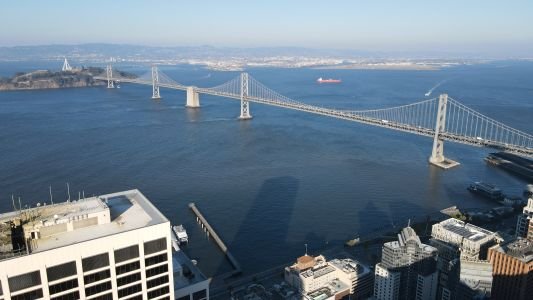
Bay Bridge was first “ordered” into existence in 1872 by Joshua Norton, a San Francisco eccentric who called himself Emperor of the United States and issued decrees demanding a bridge from the city to Oakland. It took another 64 years, but the San Francisco–Oakland Bay Bridge finally opened on November 12, 1936, six months before the Golden Gate Bridge. It carries Interstate 80 about 4.5 miles across San Francisco Bay, from downtown San Francisco to Yerba Buena Island and on to Oakland. It’s really two different bridges joined in the middle, and on an average day they carry around 260,000 vehicles, far more than the Golden Gate.
Bay Bridge Key Facts
| Detail | Information |
| Official name | San Francisco–Oakland Bay Bridge (west span also named the Willie L. Brown Jr. Bridge) |
| Location | San Francisco Bay, between downtown San Francisco, Yerba Buena Island and Oakland, California, USA |
| Coordinates | Approx. 37.7983° N, 122.3778° W |
| Highway | Interstate 80 |
| Operator | California Department of Transportation (Caltrans), with the Bay Area Toll Authority (BATA) |
| Construction began | July 9, 1933 |
| Opened | November 12, 1936 |
| Original chief engineer | Charles H. Purcell |
| Original cost | About $77 million |
| New east span opened | September 2, 2013 |
| Total length (water crossing) | About 4.5 miles (7.2 km) |
| West span | Two suspension bridges joined at a central anchorage; main spans of 2,310 ft (704 m) each |
| West span tower height | About 526 ft (160 m) above the water |
| West span clearance | About 220 ft (67 m) |
| Yerba Buena Island tunnel | 76 ft wide, 58 ft high, double-decked |
| East span | About 2.2 miles, featuring a self-anchored suspension span |
| East span tower height | 525 ft (160 m) |
| Self-anchored suspension span | 2,047 ft (624 m) total, the longest of its kind in the world |
| Decks (west span) | Upper deck westbound to San Francisco; lower deck eastbound to Oakland |
| Vehicle lanes | 10 (5 in each direction) |
| Average daily traffic | About 260,000 vehicles |
| Toll direction | Westbound only (into San Francisco) |
| Toll, 2026 | $8.50 for cars (FasTrak, License Plate Account or invoice) |
| Carpool toll | $4.25 (3+ people, weekdays 5–10 am and 3–7 pm, carpool lane, FasTrak) |
| Cash tolls | Not accepted |
| Bike and pedestrian path | Alexander Zuckermann Bay Bridge Trail, east span only (Oakland to Yerba Buena Island) |
| Time zone | Pacific Time: UTC−8 (PST), UTC−7 (PDT, second Sunday in March to first Sunday in November) |
Two Bridges and an Island
The easiest way to understand the Bay Bridge is to picture it in three parts.
The west span runs from the Rincon Hill area of San Francisco, near the Embarcadero, to Yerba Buena Island. It’s the original 1936 structure: two suspension bridges end to end, connected by a massive concrete anchorage sunk into the middle of the bay. From the waterfront, its four silver towers line up in a row.
In the middle is Yerba Buena Island, a rocky outcrop that lies within San Francisco city limits. The roadway bores straight through the island in a double-decked tunnel. When it opened, this was the largest-diameter bore tunnel in the world.
The east span continues from the island to Oakland. The original steel truss span was replaced in 2013 by a sleek new crossing with a single white tower. It ends at the toll plaza on the Oakland side, where I-80 connects to I-580 and I-880 in an interchange known locally as “the Maze.”
How Long and How High
Across the water, the bridge covers about 4.5 miles. With its approaches, the total is closer to 8 miles, which makes it one of the longest bridges in the United States. Here’s how the numbers break down:
- The west span’s two main suspension spans are each 2,310 feet long, and its towers rise about 526 feet above the water.
- The west span gives ships about 220 feet of clearance, enough for the container ships and cruise liners heading into San Francisco and Oakland.
- The east span stretches about 2.2 miles, mostly on a low skyway that climbs gradually toward the island.
- Its single tower rises 525 feet, almost exactly the same height as the west span’s towers.
- The self-anchored suspension section is 2,047 feet long in total, the longest bridge of its type anywhere.
A self-anchored suspension bridge anchors its main cable to the ends of its own deck instead of to huge blocks of concrete on land. On the Bay Bridge, one continuous main cable loops from the east end of the deck, over the tower, around the west end at Yerba Buena Island, and back again. It’s an unusual design, and it gives the east span a clean, modern profile.
Paying the Toll in 2026
Drivers pay only when heading west into San Francisco. The trip to Oakland is free. The bridge is fully cashless. Tolls at the seven state-owned Bay Area bridges rose by 50 cents on January 1, 2026, the first of five yearly increases planned through 2030.
| Vehicle/payment | Toll |
| Car with FasTrak | $8.50 |
| Car with License Plate Account or invoice | $8.50 |
| Carpool (3+ people, weekday peak) | $4.25 |
- The carpool discount applies weekdays from 5 to 10 am and 3 to 7 pm. You need at least three people, the dedicated carpool lane, and a FasTrak tag.
- The Bay Bridge is the only state-owned bridge where a standard FasTrak tag qualifies for the carpool rate. The other bridges require a FasTrak Flex tag set to “3+.”
- In 2026, every payment method pays the same rate. Starting in 2027, a tiered structure is planned that makes non-FasTrak payment cost more.
- A daily commuter crossing 250 workdays a year spends about $2,125 in tolls. Carpooling at peak times would cut that in half.
- If you’re touring both big bridges, remember that the Golden Gate Bridge has its own tolls, set by a separate agency.
Building the 1936 Bridge
By the 1920s, ferries were carrying tens of millions of passengers a year across the bay, and the crossing was slow and crowded. After years of studies, the state approved the project in 1929, with federal help through the Reconstruction Finance Corporation. Construction began on July 9, 1933, under chief engineer Charles H. Purcell.
The work set several engineering records. The central anchorage in the west span was built on a foundation sunk deeper into the bay floor than any bridge pier had been before. Crews dug the Yerba Buena Island tunnel through solid rock. The east span, a mix of cantilever and truss sections, carried the roadway across the shallower eastern side of the bay.
The bridge opened on November 12, 1936, and was finished ahead of schedule. For its first two decades, the lower deck carried electric trains of the Key System and other rail lines. When the tracks came out in the late 1950s, the bridge was reconfigured so that each deck carried traffic in one direction.
A New East Span for a New Century
The 1989 Loma Prieta earthquake showed that the old east span needed to be replaced with a structure designed for modern seismic standards. After years of design and construction, the new east span opened to traffic on September 2, 2013.
The new span is built to withstand the strongest earthquake expected in the region over the next 1,500 years. Its tower is made of four separate steel legs linked by shear links, which are designed to absorb the force of an earthquake. Along the south side of the new span runs a wide path for cyclists and pedestrians, something the original bridge never had.
The old east span was taken down in stages and fully removed by 2017. Some of its foundations were saved and turned into public viewing piers at Gateway Park, near the Oakland touchdown.
The Bay Lights
In 2013, artist Leo Villareal installed 25,000 LED lights along the west span’s vertical cables. The Bay Lights became the world’s largest light sculpture, with ever-changing patterns that could be seen from the Embarcadero. After a refresh, the installation returned in 2025 as Bay Lights 360, lit on both sides of the span so it can be seen from all around the bay. The best viewing spots include Rincon Park, Pier 14 and the waterfront near the Ferry Building.
Walking or Biking the East Span
The Alexander Zuckermann Bay Bridge Trail runs from the Oakland shoreline to Yerba Buena Island, about 3.5 miles each way from the trailhead near the toll plaza. The west span has no path, so you can’t walk or bike to San Francisco.
- The trail starts near the corner of Maritime Street and Burma Road in Oakland. The Emeryville and West Oakland shoreline paths connect to it.
- The path is wide and gently sloped, so it’s easy on foot and a fairly gentle ride by bike.
- On Yerba Buena Island, a vista point looks back along the new span. Short trails lead to views of San Francisco and the historic officer’s quarters on the island.
- Check the trail hours before you go. The path closes overnight and occasionally for maintenance.
- Bring a layer. The wind over the middle of the bay can make it feel much colder than on shore.
A Few Facts That Surprise Visitors
- The Bay Bridge is older than the Golden Gate Bridge, by about six months.
- Emperor Norton’s demand for a bridge is so well known that local groups have long campaigned to name part of the bridge after him.
- The west span’s central anchorage is taller than many downtown buildings, but most of it is hidden underwater.
- The Maze at the Oakland end is one of the busiest freeway interchanges in the country, handling traffic from three interstates.
FAQs
Q1. How much is the Bay Bridge toll in 2026?
The toll is $8.50 for cars, whether you pay with FasTrak, a License Plate Account or an invoice. Carpools of three or more pay $4.25 during weekday peak hours.
Q2. Do you pay the Bay Bridge toll both ways?
No. The toll is charged only when driving west into San Francisco. Driving east to Oakland is free.
Q3. How long is the Bay Bridge?
The crossing is about 4.5 miles across the water, and closer to 8 miles including the approaches.
Q4. How tall is the Bay Bridge?
The west span’s towers rise about 526 feet above the water, and the east span’s single tower is 525 feet tall.
Q5. When was the Bay Bridge built?
Construction began on July 9, 1933, and the bridge opened on November 12, 1936. The new east span opened in 2013.
Q6. Is the Bay Bridge older than the Golden Gate Bridge?
Yes. The Bay Bridge opened about six months before the Golden Gate Bridge, which opened in May 1937.
Q7. Can you walk across the Bay Bridge?
Only the east span. The Bay Bridge Trail runs from Oakland to Yerba Buena Island, but there’s no path on the west span into San Francisco.
Q8. What are the lights on the Bay Bridge?
They’re the Bay Lights, an LED art installation by Leo Villareal on the west span’s cables. It returned in 2025 as Bay Lights 360.
Q9. What is the tunnel on the Bay Bridge?
It’s the Yerba Buena Island tunnel, which connects the west and east spans. When it opened, it was the largest-diameter bore tunnel in the world.
Q10. What is a self-anchored suspension span?
It’s a suspension bridge whose main cable is anchored to the bridge deck itself, not to separate anchorages on land. The Bay Bridge has the longest such span in the world.
Post Comment