Brooklyn Bridge, New York, NY: Location, Length, Height, Toll, History & Facts
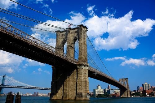
Brooklyn Bridge opened on May 24, 1883, and more than 150,000 people walked across it that first day, each paying a one-cent toll. Today, crossing costs nothing. The bridge links Lower Manhattan to Brooklyn over the East River, and on an average day it carries around 103,000 vehicles, about 29,000 pedestrians and roughly 5,500 cyclists. When it opened, it was the longest suspension bridge in the world and the first to be hung from steel wire. Its granite towers were the tallest structures in New York apart from church steeples. More than 140 years later, the walk across its raised wooden promenade is still one of the best free things to do in the city.
Brooklyn Bridge Quick Facts
| Detail | Information |
| Location | East River, between Lower Manhattan (City Hall/Civic Center) and Brooklyn (DUMBO/Brooklyn Heights), New York City, NY, USA |
| Coordinates | Approx. 40.7061° N, 73.9969° W |
| Bridge type | Hybrid suspension/cable-stayed bridge |
| Designer | John A. Roebling |
| Chief engineer after 1869 | Washington A. Roebling |
| Construction | 1869–1883 |
| Opened | May 24, 1883 |
| Original name | New York and Brooklyn Bridge (officially renamed Brooklyn Bridge in 1915) |
| Operator | New York City Department of Transportation (NYC DOT) |
| Total length (with approaches) | 6,016 ft (1,834 m) |
| Main span | 1,595.5 ft (486 m) |
| Clearance at center | 135 ft (41 m) |
| Tower height above water | About 276 ft (84 m) |
| Tower materials | Granite and limestone |
| Main cables | 4, each about 15¾ in (40 cm) in diameter |
| Vehicle lanes | 5 (cars only, no trucks) |
| Bike lane | Two-way protected lane on the former Manhattan-bound roadway (since September 2021) |
| Pedestrian promenade | Raised wooden walkway above the roadway, open 24 hours |
| Average daily traffic (2024) | 103,051 vehicles; 28,845 pedestrians; 5,504 cyclists |
| Toll | None for cars, pedestrians or cyclists |
| Landmark status | National Historic Landmark (1964); NYC Landmark (1967); National Historic Civil Engineering Landmark (1972) |
| Nearest subway (Manhattan) | Brooklyn Bridge–City Hall (4, 5, 6); Chambers St (J, Z) |
| Nearest subway (Brooklyn) | High St (A, C); York St (F) |
| Time zone | Eastern Time: UTC−5 (EST), UTC−4 (EDT, second Sunday in March to first Sunday in November) |
No Toll, in Any Direction
You won’t find a toll gantry anywhere on the Brooklyn Bridge. The city-run East River crossings (Brooklyn, Manhattan, Williamsburg and Queensboro) are all free, while crossings run by MTA Bridges and Tunnels, such as the Verrazzano-Narrows, charge tolls. It wasn’t always free. The bridge collected a penny from walkers until 1891, and roadway tolls lasted until 1911.
There are two catches for drivers. The bridge carries only passenger vehicles, so trucks, commercial vans and buses are banned. And because the bridge is free, it’s usually slower. At rush hour, the Brooklyn-bound lanes can back up onto the FDR Drive. For many trips, the Manhattan Bridge a few blocks north is faster.
Where to Step On: Manhattan and Brooklyn Entrances
On the Manhattan side, the walkway begins on Centre Street, facing City Hall Park. The Brooklyn Bridge–City Hall subway station sits practically at the ramp. In spring 2026, NYC DOT began rebuilding this entrance so that cyclists and pedestrians get separate approaches. Until then, the two groups had to merge into the same funnel, and the crush at the Manhattan end was often worse than anywhere on the span itself.
In Brooklyn, there are two ways on. The main ramp starts at Tillary Street and Boerum Place, near Cadman Plaza. The other is a staircase on Washington Street in DUMBO, which drops you almost straight onto the promenade. It’s also the quicker exit if you’re heading for the Washington Street photo spot, where the Manhattan Bridge is framed between old brick warehouses, or for Pier 1 in Brooklyn Bridge Park.
The Numbers Behind the Span
The bridge measures 6,016 feet including its long approach ramps, a little over 1.1 miles. The river crossing itself, tower to tower, is 1,595.5 feet. Because the deck sits 135 feet above the water at midspan and both shorelines are low, the approaches have to run a long way inland before the roadway reaches street level.
The two towers rise roughly 276 feet above the water. Each has a pair of tall pointed Gothic arches, and the road and walkway pass through them. From the promenade you can see how thick the stonework is: the towers are solid masonry resting on timber caissons that were sunk into the riverbed. The Brooklyn caisson stopped about 44 feet below high water. The Manhattan one went down to roughly 78 feet before the engineers judged the sand and gravel firm enough to build on.
Four main cables carry the deck, each about 15¾ inches thick and made of thousands of galvanized steel wires. Diagonal stays fan out from the tower tops and give the bridge its web-like look. John Roebling designed the structure to be six to eight times stronger than he calculated it needed to be. That generous margin is one reason a bridge planned for horse carts now handles more than 100,000 cars a day.
Three Roeblings and Fourteen Years
John A. Roebling, a German-born engineer who had already built suspension bridges at Niagara Falls and Cincinnati, drew the plans. In 1869, while he was surveying the site, a ferry crushed his foot, and he died of tetanus a few weeks later. His son, Washington Roebling, took over as chief engineer at 32.
Washington spent long hours in the pressurized caissons, supervising the digging below the riverbed. He developed caisson disease, now called decompression sickness, which left him largely unable to visit the site. For much of the rest of the build, he watched progress through a telescope from his home in Brooklyn Heights.
His wife, Emily Warren Roebling, became the link between him and the job. She studied higher mathematics, cable construction and material strength so she could carry his instructions to the assistant engineers and answer their technical questions. By the end, many engineers and city officials dealt with her directly. On opening day she rode across first, carrying a rooster as a symbol of victory. A plaque on the bridge honors her alongside her husband and father-in-law.
The opening ceremony on May 24, 1883, included President Chester A. Arthur, Governor Grover Cleveland and fireworks over the East River. The next spring, showman P. T. Barnum marched 21 elephants across to show the public how sturdy the bridge was.
Stone, Steel and Change Over Time
The bridge has been reshaped several times to keep up with how New Yorkers travel:
- Cable cars, and later elevated trains, ran across the middle of the deck until 1944, and trolleys ran until 1950.
- A reconstruction between 1944 and 1954 widened each roadway from two lanes to three and strengthened the trusses.
- Ramps connecting to the FDR Drive opened in 1969.
- A $650 million rehabilitation that ran from 2010 to 2017 renewed the approaches and repainted the entire bridge.
- In 2021, one Manhattan-bound lane was turned into the two-way bike path. Since then the promenade has been for pedestrians only, and daily cycling roughly doubled over the next four years.
Walking the Promenade Without the Crowds
The walk takes about 25 to 40 minutes one way, depending on how often you stop. The promenade is open around the clock. A few things make the walk much more pleasant:
- Go before 8 am. By mid-morning on summer weekends, the stretch around the Manhattan tower gets packed with people taking photos.
- Walk from Brooklyn toward Manhattan. That way you’re facing the skyline the whole time instead of looking back over your shoulder for it.
- Stay out of the bike lane. It’s clearly marked, and cyclists come through quickly.
- The walkway has no restrooms or shade. Plan for that on hot days.
- Sunset gives the warmest light on the towers. On clear days, the Statue of Liberty is visible to the south.
- Vendors are no longer allowed on the promenade, which keeps the walkway open for people crossing.
Small Facts With Big Stories
- The bridge held the record for the world’s longest suspension span for 20 years, until the Williamsburg Bridge opened upriver in 1903.
- Wine was once stored in the cool vaults under the Manhattan approach. The city rented out the space to help cover the bridge’s costs.
- The bridge has appeared in more films, paintings and poems than most New York landmarks. Hart Crane’s poem The Bridge and Joseph Stella’s paintings are two of the best known.
- The main arches were designed in a Gothic style, a deliberate echo of cathedral architecture.
- The bridge’s full, colorful story includes the fact that the pedestrian toll was dropped less than a decade after opening. It was one of the earliest free public walkways over a major river anywhere.
- For its 100th birthday in 1983, the city put on a fireworks show over the East River, and huge crowds walked the promenade.
FAQs
Q1. Is there a toll on the Brooklyn Bridge?
No. The Brooklyn Bridge is free for cars, cyclists and pedestrians in both directions.
Q2. How long is the Brooklyn Bridge?
The total length, including approaches, is 6,016 feet, about 1.1 miles. The main span between the towers is 1,595.5 feet.
Q3. How tall is the Brooklyn Bridge?
The towers rise about 276 feet above the water, and the deck sits 135 feet above the river at the center.
Q4. When was the Brooklyn Bridge built?
Construction ran from 1869 to 1883, and the bridge opened on May 24, 1883.
Q5. Who built the Brooklyn Bridge?
John A. Roebling designed it, his son Washington Roebling completed it, and Emily Warren Roebling played a key role in managing the work.
Q6. How long does it take to walk the Brooklyn Bridge?
Most people take 25 to 40 minutes to walk it one way, including photo stops.
Q7. Is the Brooklyn Bridge open 24 hours?
Yes. The pedestrian promenade and the bike lane are open around the clock.
Q8. Can trucks drive on the Brooklyn Bridge?
No. Only passenger vehicles are allowed, so trucks and commercial vehicles have to use other crossings.
Q9. Which subway stop is closest to the Brooklyn Bridge?
In Manhattan, it’s Brooklyn Bridge–City Hall on the 4, 5 and 6 lines. In Brooklyn, High Street on the A and C lines is closest.
Q10. Where is the best place to photograph the Brooklyn Bridge?
Popular spots include Pier 1 in Brooklyn Bridge Park, Washington Street in DUMBO, and the promenade itself near the Manhattan tower early in the morning.
Post Comment