West End Bridge, Pittsburgh, PA: Location, Length, Height, Toll, History & Facts
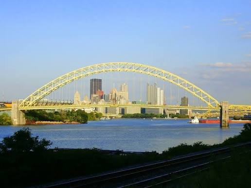
West End Bridge has one of the best views in Pittsburgh. From its deck, you look straight up the Ohio River to the Point, where the Allegheny and Monongahela rivers meet, with the downtown skyline rising behind Point State Park. The steel tied-arch bridge carries US Route 19 across the Ohio about a mile below the Point, linking the West End with the Chateau area of the North Side. When it opened on December 2, 1932, five months ahead of schedule, its main span of about 780 feet made it the longest tied-arch bridge in the world. It’s free to cross by car or on foot.
West End Bridge Key Facts
| Detail | Information |
| Other name | West End–North Side Bridge |
| Location | Ohio River, about 1 mile below the Point, between the West End (West End Circle/West Carson Street) and the Chateau/Manchester area of the North Side, Pittsburgh, Pennsylvania |
| Coordinates | Approx. 40.4463° N, 80.0270° W |
| Highway | US Route 19 |
| Owner | Allegheny County (Allegheny County Bridge No. 3 Ohio River) |
| Bridge type | Steel trussed through tied-arch (bowstring arch) |
| Designer | George S. Richardson, Allegheny County Department of Public Works |
| Builders | American Bridge Company (superstructure) and Foundation Company (substructure) |
| Construction | 1930–1932 |
| Opened | December 2, 1932 (five months ahead of schedule) |
| Original cost | About $3.64 million |
| Main span | About 778–780 ft (237 m), with about 755 ft of horizontal channel clearance |
| Total length | About 1,311 ft today (about 1,979 ft as originally built) |
| Width | About 58 ft |
| Clearance above the river | About 66 ft today (73 ft as built) |
| Lanes | 4, with pedestrian walkways on both sides |
| World record | Longest tied-arch bridge in the world when completed |
| Historic status | National Register of Historic Places (1979); Pittsburgh History and Landmarks Foundation landmark (2001) |
| Major rehabilitation | Completed 1991 |
| Toll | None |
| Time zone | Eastern Time: UTC−5 (EST), UTC−4 (EDT, second Sunday in March to first Sunday in November) |
Just Downstream From the Point
The West End Bridge crosses the Ohio River about one mile below the Point, the famous spot where Pittsburgh’s two rivers join to form the Ohio. On the south side, it lands at the West End Circle, connecting with West Carson Street (PA 837) and roads leading into the West End neighborhood and the South Hills. On the north side, it reaches the Chateau and Manchester areas of the North Side, connecting with PA 65 and roads leading toward the North Shore, the Carnegie Science Center and Route 65 north along the Ohio.
For drivers and walkers alike, the bridge’s location gives it a straight-on view of the Point, Point State Park’s fountain and the Golden Triangle skyline. It’s one of the most photographed views in the city.
A Record-Setting Tied Arch
In a tied-arch bridge, the arch rises above the roadway, and its two ends are “tied” together by the deck, like the string on an archer’s bow. This lets the arch carry heavy loads without massive foundations to resist its outward push, which made it a good fit for the soft riverbanks and navigation rules here.
- The main arch span is about 778 to 780 feet, with about 755 feet of open channel for river traffic.
- When completed in 1932, it was the longest tied-arch bridge in the world, and only the second long-span tied-arch bridge in the United States, after the Tacony–Palmyra Bridge in Philadelphia.
- The roadway hangs from steel wire-rope hangers that were pre-stressed, an innovative technique in the United States at the time, so the deck wouldn’t sag under heavy loads.
- The bridge is about 58 feet wide and carries four traffic lanes plus walkways on both sides.
- Its original length, including long Warren pony truss approaches, was about 1,979 feet. After the approaches were rebuilt, the bridge is about 1,311 feet long today.
- The deck had 73 feet of clearance above the river when built. Today the figure is about 66 feet.
Free to Cross
There’s no toll on the West End Bridge. Tips for visiting:
- Drivers use four lanes of US Route 19 between the West End and the North Side.
- Pedestrians can use walkways on both the upstream and downstream sides. The upstream walkway has the famous view of the Point.
- The walk across takes about 10 minutes.
- Sunset and evening are great times to visit, when the downtown skyline lights up across the water.
Building the Bridge
People in Pittsburgh had pushed for a bridge between the industrial North Side and the growing communities of the West End and the South Hills for about 25 years. Allegheny County finally moved ahead in the late 1920s.
Engineer George S. Richardson of the Allegheny County Department of Public Works designed the bridge. Because of navigation requirements on the Ohio River, he chose a tied-arch design, rarely used for such a long span at the time. The Foundation Company built the piers, and the American Bridge Company built the steel superstructure. Construction began in 1930 and moved quickly.
The bridge was dedicated on December 2, 1932, five months ahead of schedule, at a cost of about $3.64 million. Seven-year-old Mary Hershberger, granddaughter of County Commissioner Henry Tranter, cut the ribbon to open it. Tranter called the opening an “epoch” in the history of Pittsburgh and Allegheny County.
Richardson went on to design several more of Pittsburgh’s best-known bridges, including the Fort Pitt and Fort Duquesne bridges at the Point in the 1950s.
Upgrades Over the Years
To keep the bridge in good shape for modern traffic, Allegheny County carried out a major rehabilitation that was completed in 1991. The approaches were reconstructed and shortened, which is why the bridge is shorter today than when it was first built. More recent work has improved the bridge’s approaches and surrounding roads.
The bridge’s engineering and appearance earned it a place on the National Register of Historic Places in 1979, and it was named a Pittsburgh History and Landmarks Foundation landmark in 2001.
Things to Do Nearby
- Point State Park, upriver at the Point, has its famous fountain, riverside lawns and the Fort Pitt Museum.
- The Carnegie Science Center, on the North Shore, has hands-on exhibits, a planetarium and a submarine you can tour.
- The West End Overlook, in a park high above the West End, has a panoramic view of the bridge, the rivers and downtown.
- Mount Washington’s Grandview Avenue offers sweeping views of all three rivers and the bridges.
- The Three Rivers Heritage Trail runs along the North Shore, close to the bridge’s north end.
FAQs
Q1. Is there a toll on the West End Bridge?
A. No. The West End Bridge is free to cross.
Q2. How long is the West End Bridge?
A. The main arch span is about 778 to 780 feet, and the bridge is about 1,311 feet long today.
Q3. How high is the West End Bridge?
A. The deck sits about 66 feet above the Ohio River today, compared with 73 feet when it was built.
Q4. When was the West End Bridge built?
A. It was built between 1930 and 1932 and opened on December 2, 1932.
Q5. What type of bridge is the West End Bridge?
A. It’s a steel tied-arch bridge, also called a bowstring arch.
Q6. Was the West End Bridge ever a world record?
A. Yes. When it opened, it was the longest tied-arch bridge in the world.
Q7. Who designed the West End Bridge?
A. It was designed by George S. Richardson of the Allegheny County Department of Public Works.
Q8. What does the West End Bridge connect?
A. It connects Pittsburgh’s West End with the Chateau and Manchester areas of the North Side, carrying US Route 19.
Q9. Can you walk across the West End Bridge?
A. Yes. There are pedestrian walkways on both sides of the bridge.
Q10. What is the view from the West End Bridge?
A. It has a straight-on view up the Ohio River to the Point, with the downtown Pittsburgh skyline behind it.







Post Comment