Carquinez Bridge, Vallejo, CA: Location, Length, Height, Toll, History & Facts
Carquinez Bridge is really two bridges side by side, built nearly half a century apart. One is a classic 1958 steel cantilever truss, and the other is a graceful 2003 suspension bridge with tall white concrete towers. Together they carry Interstate 80 across the Carquinez Strait, the narrow waterway where the Sacramento and San Joaquin rivers flow toward San Francisco Bay, between Crockett and Vallejo. The newer span is officially named the Alfred Zampa Memorial Bridge, after an ironworker who helped build many of the Bay Area’s great bridges. Its 2,388-foot main span is one of the longest suspension spans in the country. Drivers pay only heading east into Vallejo: $8.50 in 2026.

Carquinez Bridge Key Facts
| Detail | 1958 Span (Eastbound) | 2003 Alfred Zampa Memorial Bridge (Westbound) |
| Location | Carquinez Strait, between Crockett (Contra Costa County) and Vallejo (Solano County), California | Same |
| Highway | Interstate 80 | Interstate 80 |
| Bridge type | Steel cantilever truss | Suspension bridge |
| Opened | November 25, 1958 | November 11, 2003 (dedicated November 8, 2003) |
| Cost | About $38 million | About $240 million |
| Length | About 0.8 miles (roughly 3,300 ft) | About 3,465 ft (0.66 miles) |
| Main span | About 1,100 ft | 2,388 ft |
| Tower height | 314 ft | 420 ft (north tower); 403 ft (south tower) |
| Vertical clearance | About 140 ft | About 148 ft |
| Lanes | 4 eastbound | 4 westbound, plus a bike and pedestrian path |
| Designer | California Division of Highways | Parsons, for Caltrans |
| Toll | $8.50 (eastbound only, into Vallejo) | None |
| Other Details | Information |
| Coordinates | Approx. 38.0610° N, 122.2260° W |
| Original 1927 bridge | Steel cantilever opened May 21, 1927; removed by September 4, 2007 |
| Carpool toll | $4.25 (FasTrak only, weekday rush hours) |
| Payment | All-electronic (no cash) |
| Annual toll-paid vehicles | About 20.6 million (FY 2022–23) |
| Named for (2003 span) | Alfred “Al” Zampa, Bay Area ironworker |
| Time zone | Pacific Time: UTC−8 (PST), UTC−7 (PDT, second Sunday in March to first Sunday in November) |
Over the Carquinez Strait
The Carquinez Strait is a narrow, deep channel that connects San Pablo Bay, part of San Francisco Bay, with Suisun Bay and the Sacramento–San Joaquin River Delta to the east. Ocean-going ships pass through it on their way to ports at Stockton and Sacramento.
On the south side, the bridges begin in Crockett, a small hillside town known for the giant C&H Sugar refinery on its waterfront. On the north side, they land in Vallejo, home to Six Flags Discovery Kingdom and the historic Mare Island shipyard. Interstate 80 continues north toward Sacramento, Lake Tahoe and the Napa Valley wine country, making this one of the busiest crossings in Northern California.
Two Bridges, Two Designs
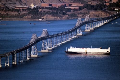
The 1958 cantilever bridge carries eastbound traffic toward Vallejo:
- It’s about 0.8 miles long, with a main span of about 1,100 feet.
- Its steel towers rise 314 feet, and the deck gives ships about 140 feet of clearance.
- It carries four lanes and was strengthened with a seismic retrofit after the newer bridge opened.
The 2003 Alfred Zampa Memorial Bridge carries westbound traffic toward Crockett and the Bay Area:
- It’s about 3,465 feet long, with a main span of 2,388 feet.
- Its two hollow concrete towers rise 420 feet (north) and 403 feet (south).
- A sleek steel box girder deck, 95 feet wide, carries four lanes plus a bike and pedestrian path.
- The towers stand on deep drilled shafts in the strait, and the deck gives ships about 148 feet of clearance.
Paying the Toll
Tolls are collected only from eastbound drivers, heading toward Vallejo, at the toll plaza in Crockett. The westbound trip on the Zampa Bridge is free. The bridge is fully cashless.
| Payment method | Car toll (2026) |
| FasTrak | $8.50 |
| License plate account, one-time payment or invoice | $8.50 |
| Carpool (3+ people, FasTrak Flex) | $4.25 |
Tips for drivers:
- The carpool discount applies on weekdays during morning and evening rush hours for vehicles with three or more people using a FasTrak Flex tag set to “3+.”
- Tolls on the Bay Area’s state-owned bridges are scheduled to rise each year through 2030.
- Pomona Street in Crockett is the last exit before the toll plaza heading east.
- Weekend traffic toward Napa, Sacramento and Lake Tahoe can be heavy, especially on Friday afternoons.
Walking and Biking the Zampa Bridge
The Alfred Zampa Memorial Bridge has a separated path for walkers and cyclists, known as the Carquinez Bridge Trail. It’s part of the San Francisco Bay Trail and offers spectacular views:
- Look east up the Carquinez Strait toward the Delta and the Benicia-Martinez Bridge.
- Look west toward San Pablo Bay and Mare Island.
- See the 1958 cantilever bridge right alongside, a great way to compare the two designs.
- It’s often windy on the bridge, so bring a jacket.
The Original 1927 Bridge
The first Carquinez Bridge opened on May 21, 1927, as a privately built toll bridge. Designed with input from noted bridge engineer David B. Steinman, it was a massive steel cantilever bridge that used about 13,000 tons of steel and cost about $8 million. It carried the Lincoln Highway, America’s first coast-to-coast road, across the strait, replacing ferry service and greatly speeding travel between the Bay Area and Sacramento.
As traffic grew, a parallel cantilever bridge was built and opened on November 25, 1958. The 1958 span took over eastbound traffic, and the original 1927 span handled westbound traffic.
The Alfred Zampa Memorial Bridge
After the 1989 Loma Prieta earthquake, engineers studied the older bridges and decided to replace the 1927 span with a new bridge built to modern seismic standards. Caltrans, working with the engineering firm Parsons, chose a suspension bridge design. The new bridge was dedicated on November 8, 2003, and opened to traffic on November 11, 2003. The 1927 span was then removed piece by piece, a job completed by September 2007.
The new bridge honors Alfred “Al” Zampa, a Bay Area ironworker who helped build many of the region’s landmark bridges, including the original Carquinez Bridge, the Bay Bridge and the Golden Gate Bridge. On the Golden Gate, Zampa survived a fall into the safety net and became one of the famous members of the “Halfway to Hell Club.” It was the first major bridge in the United States named after a working ironworker.
Things to Do Nearby
- Crockett, at the bridges’ south end, is a charming small town with waterfront restaurants and views of the strait.
- Carquinez Strait Regional Shoreline offers hiking trails high above the water with views of both bridges.
- Mare Island, in Vallejo, features a historic naval shipyard, a museum and a nature preserve.
- Six Flags Discovery Kingdom, in Vallejo, combines a theme park with animal exhibits.
- The Napa Valley, a short drive north, is famous for its wineries.
FAQs
Q1. How much is the Carquinez Bridge toll in 2026?
A. The Carquinez Bridge toll is $8.50 for cars, collected only on eastbound trips toward Vallejo. Eligible carpools pay $4.25 during designated weekday commute hours.
Q2. Is the Carquinez Bridge toll charged both ways?
A. No. Tolls are collected only in the eastbound direction, at the toll plaza in Crockett.
Q3. Does the Carquinez Bridge accept cash?
A. No. The Carquinez Bridge uses all-electronic tolling. Drivers can pay through FasTrak, a license plate account, a one-time payment, or an invoice.
Q4. How long is the Carquinez Bridge?
A. The 2003 suspension bridge is approximately 3,465 feet long, while the 1958 cantilever bridge is about 0.8 miles long.
Q5. How high is the Carquinez Bridge?
A. The suspension bridge’s towers rise to approximately 420 feet, while the bridge deck provides about 148 feet of clearance above the Carquinez Strait.
Q6. When did the Carquinez Bridge open?
A. The original Carquinez Bridge opened in 1927. The cantilever span opened in 1958, while the newer suspension span opened on November 11, 2003.
Q7. Why is it called the Alfred Zampa Memorial Bridge?
A. The 2003 suspension span is named the Alfred Zampa Memorial Bridge in honor of Al Zampa, an ironworker who worked on the original Carquinez Bridge as well as the Bay Bridge and Golden Gate Bridge.
Q8. Can you walk or bike across the Carquinez Bridge?
A. Yes. The 2003 suspension bridge includes a separated pedestrian and bicycle path, allowing people to walk or cycle across the Carquinez Strait.
Q9. What highway crosses the Carquinez Bridge?
A. Interstate 80 (I-80) crosses the Carquinez Strait via the bridges, connecting Crockett in Contra Costa County with Vallejo in Solano County.
Q10. What does the Carquinez Strait connect?
A. The Carquinez Strait connects San Pablo Bay with Suisun Bay, forming an important water passage between the San Francisco Bay system and the Sacramento–San Joaquin River Delta.






Post Comment