Verrazzano-Narrows Bridge, New York, NY: Location, Length, Height, Toll, History & Facts
Verrazzano-Narrows Bridge is where the New York City Marathon begins. Every November, more than 50,000 runners pour across its upper deck from Staten Island toward Brooklyn, one of the few times each year it’s open to anyone on foot. The rest of the year, the bridge carries Interstate 278 over the Narrows, the tidal strait at the entrance to New York Harbor. It opened on November 21, 1964. Its 4,260-foot main span was then the longest in the world, and it is still the longest suspension span anywhere in the Americas. Every large ship entering the harbor from the Atlantic passes beneath it.
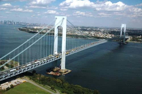
Verrazzano-Narrows Bridge Overview
| Detail | Information |
| Location | The Narrows, between Fort Wadsworth (Staten Island) and Fort Hamilton/Bay Ridge (Brooklyn), New York City, NY, USA |
| Coordinates | Approx. 40.6066° N, 74.0447° W |
| Highway | Interstate 278 (Staten Island Expressway to Gowanus Expressway/Belt Parkway) |
| Bridge type | Double-decked suspension bridge |
| Chief engineer | Othmar H. Ammann |
| Builder/operator | Triborough Bridge and Tunnel Authority (now MTA Bridges and Tunnels) |
| Construction began | August 1959 |
| Upper deck opened | November 21, 1964 |
| Lower deck opened | June 28, 1969 |
| Original cost | About $320 million |
| Named for | Giovanni da Verrazzano, Italian explorer (1524) |
| Main span | 4,260 ft (1,298 m) |
| Total length (with approaches) | About 13,700 ft (4,176 m) |
| Tower height | 693 ft (211 m) above the water |
| Clearance at midspan | About 228 ft (69 m) |
| Main cables | 4, each about 36 in (91 cm) in diameter |
| Vehicle lanes | 12 (6 on each level) |
| Pedestrian/bike access | None, except on New York City Marathon day and for special events |
| Toll direction | Both directions (split tolling since December 2020) |
| Toll: NY E-ZPass | $7.46 each way |
| Toll: Mid-Tier (NY E-ZPass not read) | $9.79 each way |
| Toll: Tolls by Mail / non-NY E-ZPass | $12.03 each way |
| Toll: Staten Island residents (E-ZPass plan) | $2.75 effective after MTA rebate ($4.19 without the rebate) |
| Tolls effective | January 4, 2026 |
| Cash tolls | Not accepted (open road tolling since 2017) |
| Time zone | Eastern Time: UTC−5 (EST), UTC−4 (EDT, second Sunday in March to first Sunday in November) |
Where the Harbor Meets the Sea
The Narrows is only about a mile wide at its narrowest point. It’s the gateway between Upper New York Bay, with the Statue of Liberty and Manhattan, and Lower New York Bay, which opens to the Atlantic. Two old military posts stand at either end of the bridge. Fort Wadsworth on Staten Island is one of the oldest military sites in the United States, and Fort Hamilton in Brooklyn is still an active Army garrison.
On the Brooklyn side, the bridge comes down in the Bay Ridge neighborhood and connects with the Gowanus Expressway and the Belt Parkway. On the Staten Island side, it feeds straight into the Staten Island Expressway, which continues to the Goethals Bridge and New Jersey. For truck traffic and long-distance drivers, the bridge is a key link between New Jersey, Long Island and the rest of the Northeast that bypasses Manhattan entirely.
Towers That Lean for the Earth
The two towers stand 4,260 feet apart and rise 693 feet above the water. They’re so tall and so far apart that Othmar Ammann’s engineers had to account for the curvature of the Earth. The towers are about 1⅝ inches farther apart at the top than at the base, because each one points straight up relative to the ground beneath it, and the ground itself curves.
Other measurements tell a similar story:
- The four main cables are each roughly three feet thick. The wire inside them adds up to about 143,000 miles, enough to reach more than halfway to the Moon.
- In summer heat, the steel cables stretch, and the deck at midspan can sit about 12 feet lower than it does on a cold winter day.
- The deck clears the water by about 228 feet at midspan, enough for most ocean liners and container ships. Some of the largest modern cruise ships were designed with this bridge’s clearance in mind.
- Including its long approach viaducts, the bridge stretches about 13,700 feet, roughly 2.6 miles.
The main span held the world record for 17 years, until England’s Humber Bridge opened in 1981. It remains the longest suspension span in the Western Hemisphere, 60 feet longer than the Golden Gate Bridge.
What It Costs to Cross
Since December 2020, tolls have been collected in both directions. For decades before that, the bridge had federally mandated one-direction tolling, and only drivers entering Staten Island paid. The switch to split tolling kept the round-trip cost the same but divided it evenly between the two directions. The bridge has been fully cashless since 2017.
| Payment method | Toll per crossing (car) |
| NY E-ZPass | $7.46 |
| Mid-Tier (NY E-ZPass not read) | $9.79 |
| Tolls by Mail or out-of-state E-ZPass | $12.03 |
| Staten Island resident E-ZPass plan | $2.75 (after MTA rebate) |
Tips for drivers:
- A round trip costs $14.92 with NY E-ZPass, compared with $24.06 by Tolls by Mail. Over a year of weekday round trips, that’s a difference of more than $2,000.
- The lower rate applies only to E-ZPass accounts issued in New York. Drivers with an E-ZPass tag from another state pay the Tolls by Mail rate.
- Staten Island residents need to register their vehicles for the resident plan to get the $2.75 rate.
- Make sure your tag is mounted properly behind the rearview mirror. If the reader can’t pick it up, the Mid-Tier rate of $9.79 applies.
- The bridge is well outside Manhattan’s Congestion Relief Zone, so no zone charge applies.
The Last Great Bridge of Othmar Ammann
Plans to link Staten Island with Brooklyn go back to the 1880s, and there were proposals for tunnels in the 1920s and 1930s. The idea didn’t gain real momentum until the late 1940s, when urban planner Robert Moses championed a bridge across the Narrows as a way to connect Staten Island with the rest of the city’s highway network.
Moses hired Othmar Ammann, who had already designed the George Washington Bridge, the Bayonne Bridge and the Throgs Neck Bridge. The Verrazzano-Narrows was the crowning project of Ammann’s career. Construction began in August 1959. Crews built the towers, spun the cables and hung the deck in just over five years, and the upper deck opened on November 21, 1964.
The lower deck opened in June 1969, doubling the bridge’s capacity to 12 lanes. As with the George Washington Bridge, Ammann had designed the structure to carry a second deck from the very start.
A Name With a Double Z
The bridge honors Giovanni da Verrazzano, the Italian explorer who, in 1524, became the first European to sail into New York Harbor. For more than 50 years the name was officially spelled “Verrazano,” with a single z. After a campaign by Italian-American groups and others, New York State corrected the spelling in 2018 to match the explorer’s own name, and the road signs were updated.
Monuments to Verrazzano stand in Battery Park in Manhattan and at Fort Wadsworth, not far from the bridge’s Staten Island end.
The Marathon Start Line
The New York City Marathon has started on the bridge since 1976, when the race expanded to all five boroughs. On race morning, the Staten Island toll plaza area becomes a staging ground, and runners start in waves on both the upper and lower decks. Many say the first mile, climbing up and over the main span with the harbor on both sides, is the most memorable part of the whole race.
The bridge also opens for the Five Boro Bike Tour each spring. It’s the finale of the ride, and one of the rare chances to cross the bridge on two wheels.
How to See It
Since the bridge has no public walkway, the best views are from the shore or the water:
- In Brooklyn, the Shore Road Promenade and the path along the Belt Parkway in Bay Ridge run right beneath the bridge. They’re popular for walking, cycling and fishing.
- On Staten Island, the grounds of Fort Wadsworth give a high-angle view of the towers and the harbor.
- The free Staten Island Ferry gives distant views of the bridge on clear days, framed against the Lower Bay.
- At night, a strand of LED lights along the main cables, installed in 2016, creates the bridge’s “necklace” glow.
FAQs
Q1. How much is the Verrazzano-Narrows Bridge toll in 2026?
A car pays $7.46 each way with NY E-ZPass or $12.03 by Tolls by Mail. Registered Staten Island residents pay an effective $2.75 after the MTA rebate.
Q2. Is the Verrazzano Bridge tolled in both directions?
Yes. Since December 2020, tolls have been collected both into Staten Island and into Brooklyn.
Q3. How long is the Verrazzano-Narrows Bridge?
Its main span is 4,260 feet, and the total length including approaches is about 13,700 feet.
Q4. How tall is the Verrazzano-Narrows Bridge?
The towers rise 693 feet above the water, and the deck clears the Narrows by about 228 feet at midspan.
Q5. When did the Verrazzano-Narrows Bridge open?
The upper deck opened on November 21, 1964, and the lower deck followed on June 28, 1969.
Q6. Who designed the Verrazzano-Narrows Bridge?
It was designed by Othmar H. Ammann, the engineer who also created the George Washington Bridge.
Q7. Can you walk across the Verrazzano Bridge?
No. There’s no public walkway, but runners cross it during the New York City Marathon and cyclists during the Five Boro Bike Tour.
Q8. Why is Verrazzano spelled with two Z’s?
New York State corrected the spelling in 2018 to match the explorer’s name, Giovanni da Verrazzano. The bridge had used one z since 1964.
Q9. Is the Verrazzano-Narrows the longest suspension bridge in the US?
Yes. Its 4,260-foot main span is the longest in the United States and in the Western Hemisphere.
Q10. Why are the Verrazzano towers farther apart at the top?
The towers are so tall and far apart that the Earth’s curvature makes them about 1⅝ inches farther apart at the top than at the base.






Post Comment