San Mateo-Hayward Bridge, Hayward, CA: Location, Length, Height, Toll, History & Facts
San Mateo-Hayward Bridge is the longest bridge in California, about 7 miles of roadway stretched across the middle of San Francisco Bay. It carries State Route 92 between Hayward in the East Bay and Foster City and San Mateo on the Peninsula, with a high-rise section over the shipping channel and a long, low trestle skimming just above the water. The crossing has a proud history: its 1929 predecessor was once the longest over-water bridge in the world. Today’s bridge opened in 1967 and carries about 93,000 vehicles on a typical day. Drivers pay only heading west toward San Mateo: $8.50 in 2026.
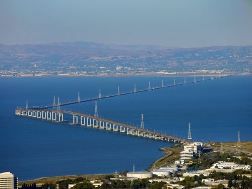
San Mateo-Hayward Bridge Key Facts
| Detail | Information |
| Common name | San Mateo Bridge |
| Location | Central San Francisco Bay, between Hayward (Alameda County) and Foster City/San Mateo (San Mateo County), California |
| Coordinates | Approx. 37.5850° N, 122.2050° W |
| Highway | State Route 92 |
| Operators | Caltrans and the Bay Area Toll Authority |
| Bridge type | Orthotropic steel girder high-rise section with a long concrete trestle |
| Current bridge dedicated | October 20, 1967 |
| Opened to traffic | October 31, 1967 |
| Original cost | About $70 million |
| Trestle widening | New westbound causeway opened November 4, 2002; widening completed January 2003 |
| Total length | About 7 miles (11.3 km) |
| High-rise section | About 1.9 miles |
| Low trestle section | About 5.1 miles |
| Main span | 750 ft (longest girder span in the US when built) |
| Back spans | 375 ft each |
| Vertical clearance | About 135 ft over the shipping channel |
| Lanes | 6 (3 each way), with full shoulders on the trestle |
| Daily traffic | About 93,000 vehicles |
| Annual toll-paid vehicles | About 15.9 million (FY 2022–23) |
| Toll direction | Westbound only (collected in Hayward) |
| Car toll (2026) | $8.50 |
| Carpool toll | $4.25 (FasTrak only, weekday rush hours) |
| Payment | All-electronic (no cash) |
| Distinction | Longest bridge in California |
| Pedestrians and cyclists | Not permitted |
| Time zone | Pacific Time: UTC−8 (PST), UTC−7 (PDT, second Sunday in March to first Sunday in November) |
Across the Middle of the Bay
The San Mateo-Hayward Bridge is one of three bridges crossing the southern half of San Francisco Bay, between the Bay Bridge to the north and the Dumbarton Bridge to the south. On the east side, it begins in Hayward and connects with Interstate 880. On the west side, it lands in Foster City, near San Mateo, and connects with US 101 and, farther on, Interstate 280.
For commuters, it’s a vital link between the East Bay’s homes and the Peninsula’s offices, including many of Silicon Valley’s major employers. It also offers a quicker route between the East Bay and San Francisco International Airport.
High-Rise and Trestle
Driving the bridge feels like two different experiences:
- The high-rise section, on the western side, runs about 1.9 miles and climbs high over the shipping channel. Its main span is 750 feet, flanked by two 375-foot back spans. When the bridge opened, its main span was the longest girder span in the United States.
- The low trestle section, on the eastern side, runs about 5.1 miles just above the water. On calm days, drivers seem to be gliding across the bay itself.
Together, the two sections stretch about 7 miles, making it California’s longest bridge. The high-rise uses an orthotropic steel deck, a lightweight design that combines the steel deck plate with ribs underneath so the deck itself helps carry loads. It’s one of the earliest major uses of this technique in the US. The channel span gives ships about 135 feet of clearance.
Paying the Toll
Tolls are collected only from westbound drivers, at the Hayward toll plaza. The trip east is free. The bridge has been fully cashless since 2020.
| Payment method | Car toll (2026) |
| FasTrak | $8.50 |
| License plate account, one-time payment or invoice | $8.50 |
| Carpool (3+ people, FasTrak Flex) | $4.25 |
Tips for drivers:
- The carpool discount applies on weekdays from 5 to 10 a.m. and 3 to 7 p.m. for vehicles with three or more people using a FasTrak Flex tag set to “3+.”
- Tolls on the Bay Area’s state-owned bridges are scheduled to rise each year through 2030.
- Strong winds often sweep across the open bay, especially in the afternoon, so keep both hands on the wheel, particularly in high-profile vehicles.
- Pedestrians and cyclists aren’t allowed on the bridge. The Dumbarton Bridge to the south has a bike and pedestrian path.
The 1929 “Longest Bridge in the World”
The idea of a bridge across the middle of the bay was first proposed in 1922. A private company raised money to build a span from Hayward to San Mateo, and on March 2, 1929, the San Francisco Bay Toll-Bridge opened after about a year of construction.
The original bridge was about 7.1 miles long, only 30 feet wide, with just two lanes. It had a vertical lift span that could rise to let ships pass, giving 35 feet of clearance when lowered and 135 feet when raised. For about two decades, it was the longest over-water bridge in the world. At its 1929 dedication, a Hayward cannery truck crossed the bridge carrying “Quality Tomato Catsup” to San Mateo.
The original toll was 45 cents. In 1951, the State of California bought the bridge, along with the Dumbarton Bridge, for $8.35 million and celebrated by lowering the toll to 35 cents.
Building the 1967 Bridge
By the late 1950s, the narrow two-lane bridge couldn’t keep up with traffic, which grew from about 3,000 cars a day in 1929 to more than 50,000 by the 1960s. The state planned a new, wider, fixed high-level bridge, built just north of the original span.
The new bridge, costing about $70 million, was dedicated on October 20, 1967, and opened to traffic on October 31, 1967. The old bridge’s steel truss spans were sold and removed after the new bridge opened. The new design won awards for its clean, modern appearance.
Widening the Trestle
The high-rise section was built with six lanes from the start, but the low trestle had only four, creating one of the Bay Area’s worst evening commutes. As part of Regional Measure 1, approved by Bay Area voters in 1988, a new westbound trestle was built alongside the original. It opened on November 4, 2002, and the full widening was completed in January 2003. The trestle now carries six lanes, matching the high-rise, with full shoulders for disabled vehicles.
Further improvements included a seismic retrofit and a new I-880/SR 92 interchange in Hayward, completed in October 2011.
Things to Do Nearby
- Coyote Point Recreation Area in San Mateo has a beach, a marina and the CuriOdyssey science museum.
- Hayward Regional Shoreline offers bayside trails, marshes and birdwatching near the bridge’s east end.
- Foster City’s lagoons and Leo J. Ryan Park are popular for kayaking, paddleboarding and waterfront strolls.
- The San Francisco Bay Trail runs along the shoreline on both sides of the bay.
- Downtown San Mateo has restaurants, shops and the Japanese Tea Garden in Central Park.
FAQs
Q1. How much is the San Mateo-Hayward Bridge toll in 2026?
A. The toll is $8.50 for cars, collected only on westbound trips. Carpools pay $4.25 during weekday rush hours.
Q2. Is the San Mateo Bridge toll charged both ways?
A. No. Tolls are collected only westbound, at the Hayward toll plaza.
Q3. Does the San Mateo-Hayward Bridge accept cash?
A. No. Tolls are fully electronic, by FasTrak, license plate account, one-time payment or invoice.
Q4. How long is the San Mateo-Hayward Bridge?
A. It’s about 7 miles long, making it the longest bridge in California.
Q5. How high is the San Mateo-Hayward Bridge?
A. The high-rise section gives ships about 135 feet of clearance over the shipping channel.
Q6. When did the San Mateo-Hayward Bridge open?
A. The current bridge opened on October 31, 1967. The original bridge opened on March 2, 1929.
Q7. Was the San Mateo Bridge ever the longest bridge in the world?
A. Yes. The original 1929 bridge was the longest over-water bridge in the world for about two decades.
Q8. Can you walk or bike across the San Mateo-Hayward Bridge?
A. No. Pedestrians and cyclists aren’t allowed. The Dumbarton Bridge has a path instead.
Q9. What highway crosses the San Mateo-Hayward Bridge?
A. State Route 92 crosses the bridge between Hayward and San Mateo.
Q10. How many lanes does the San Mateo Bridge have?
A. It has six lanes, three in each direction.






Post Comment