Richmond-San Rafael Bridge, Richmond, CA: Location, Length, Height, Toll, History & Facts
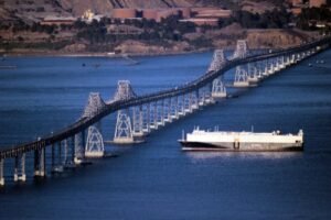
Richmond-San Rafael Bridge has a shape that drivers never forget. Its double-decked steel roadway rises over two tall humps and dips in between, a profile locals have long compared to a roller coaster or a washboard. The 5.5-mile bridge carries Interstate 580 across the northern part of San Francisco Bay, linking Richmond in the East Bay with San Rafael in Marin County. It opened on September 1, 1956, the morning after the last ferry made its final run. Since 2019, it has also offered one of the Bay Area’s most spectacular walking and biking paths. Drivers pay only heading west into Marin: $8.50 in 2026.
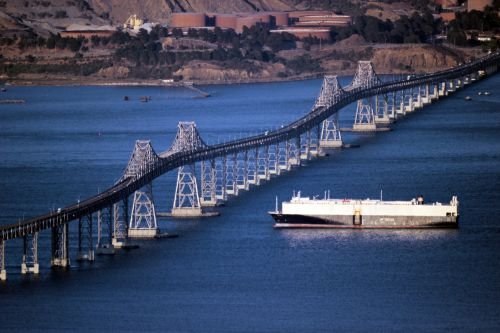
Richmond-San Rafael Bridge Key Facts
| Detail | Information |
| Official name | John F. McCarthy Memorial Bridge (named in the early 1980s) |
| Other names | Richmond Bridge; San Rafael Bridge |
| Location | Northern San Francisco Bay, near San Pablo Bay, between Point Richmond (Contra Costa County) and Point San Quentin, San Rafael (Marin County), California |
| Coordinates | Approx. 37.9350° N, 122.4370° W |
| Highway | Interstate 580 |
| Operators | Caltrans and the Bay Area Toll Authority |
| Bridge type | Double-decked steel cantilever truss with long approach trestles |
| Opened | September 1, 1956 |
| Replaced | Richmond–San Rafael Ferry service |
| Total length | 29,040 ft (5.5 miles), including approaches |
| Main spans | Two cantilever spans of about 1,070 ft each |
| Navigation clearance | About 185 ft |
| Decks | Upper deck: westbound to Marin (with the bike/pedestrian path); lower deck: eastbound to Richmond |
| Toll direction | Westbound only (collected in Richmond) |
| Car toll (2026) | $8.50 (FasTrak, license plate account, one-time payment or invoice) |
| Carpool toll | $4.25 (FasTrak only, during weekday rush hours) |
| Payment | All-electronic since March 2020 (no cash) |
| Planned toll increases | Rising each year to $10.50 by 2030 |
| Annual toll-paid vehicles | About 12.9 million (FY 2022–23) |
| Bike and pedestrian path | Opened November 2019; part of the San Francisco Bay Trail |
| Time zone | Pacific Time: UTC−8 (PST), UTC−7 (PDT, second Sunday in March to first Sunday in November) |
Linking the East Bay and Marin
The Richmond-San Rafael Bridge crosses the bay at its northern end, where San Francisco Bay meets San Pablo Bay. On the east side, it begins near Point Richmond, a charming historic neighborhood in Richmond, and connects with Interstate 80 and the Richmond Parkway. On the west side, it lands at Point San Quentin in San Rafael, where I-580 meets US 101 in Marin County.
For drivers, the bridge is the main link between the East Bay and Marin and the rest of the North Bay. It saves a long drive around San Pablo Bay or through San Francisco and the Golden Gate Bridge.
The Roller-Coaster Bridge
The bridge’s design gives it its famous shape:
- It’s 5.5 miles long, including long low trestles on both ends.
- Two high cantilever truss spans, each about 1,070 feet, rise over the shipping channels, with about 185 feet of clearance for ships.
- Between the two high spans, the roadway dips down, creating the bridge’s distinctive double-humped profile.
- It’s a double-decked bridge. Westbound traffic toward Marin uses the upper deck, and eastbound traffic toward Richmond uses the lower deck.
The two high spans let large ships reach the refineries and ports along San Pablo Bay and the Carquinez Strait, while the low trestles keep construction costs down across the shallow parts of the bay.
Paying the Toll
Tolls are collected only from westbound drivers, heading from Richmond toward San Rafael. The trip east is free. The bridge has been fully cashless since March 2020.
| Payment method | Car toll (2026) |
| FasTrak | $8.50 |
| License plate account, one-time payment or invoice | $8.50 |
| Carpool (3+ people, FasTrak Flex) | $4.25 |
Tips for drivers:
- The carpool rate applies on weekdays from 5 to 10 a.m. and 3 to 7 p.m. for vehicles with three or more people, using a FasTrak Flex tag set to “3+.”
- Tolls on the Bay Area’s seven state-owned bridges are scheduled to rise each year, reaching $10.50 by 2030.
- Morning rush hour toward Marin and evening rush hour toward Richmond can be busy. Check Caltrans and 511 traffic updates before you go.
Walking and Biking the Bridge
Since November 2019, walkers and cyclists have been able to cross the Richmond-San Rafael Bridge on a path along the upper deck, separated from car traffic by a concrete barrier. It’s part of the San Francisco Bay Trail, a planned 500-mile network circling the bay.
Tips for using the path:
- The route is about 6 miles long from Point San Quentin in San Rafael to Castro Street and Tewksbury Avenue in Point Richmond.
- The climb to the top of the high spans is steady, so many riders take it slowly or walk their bikes for part of the way.
- From the top, there are sweeping views of Mount Tamalpais, the Marin Islands, the San Francisco skyline and the bay.
- Bring layers. It’s often windy and much cooler on the bridge than on shore.
- Path hours and operations can change, so check Caltrans’s Richmond-San Rafael Bridge updates before your trip.
From Ferries to a Bridge
For decades, the only way across this part of the bay was by ferry. The Richmond–San Rafael Ferry Company carried cars and passengers between the two shores, and proposals for a fixed crossing go back to the 1920s, before the Golden Gate Bridge was built.
After World War II, traffic between the East Bay and Marin grew quickly, and the state moved ahead with a bridge. The ferries ran until the night of August 31, 1956, and the new bridge opened the next morning, September 1, 1956. At the time, it was one of the longest bridges in the world.
The John F. McCarthy Memorial Bridge
In the early 1980s, the bridge was officially named the John F. McCarthy Memorial Bridge, honoring the California state senator from Marin County who had championed its construction. Most people still simply call it the Richmond-San Rafael Bridge or the “Richmond Bridge.”
Improvements Over the Years
The bridge has been updated many times:
- 2001: The Richmond Parkway, a 7.5-mile road connecting the bridge with I-80 near Pinole, opened and greatly improved access.
- 2000s: A major seismic retrofit strengthened the bridge to withstand earthquakes.
- 2019: The bike and pedestrian path opened on the upper deck.
- 2020: Toll collection became fully electronic.
Things to Do Nearby
- Point Richmond, at the east end, is a historic village with cafés, shops and the Point Richmond Plunge, a restored historic swimming pool.
- Miller/Knox Regional Shoreline in Richmond has beaches, picnic areas and bay views.
- East Brother Light Station, a historic lighthouse on an island near the bridge, operates as a bed-and-breakfast.
- China Camp State Park in San Rafael offers trails and a historic Chinese shrimp-fishing village.
- Downtown San Rafael has the historic Mission San Rafael Arcángel, restaurants and shops.
FAQs
Q1. How much is the Richmond-San Rafael Bridge toll in 2026?
A. The toll is $8.50 for cars, collected only on westbound trips. Carpools pay $4.25 during weekday rush hours.
Q2. Is the Richmond-San Rafael Bridge toll charged both ways?
A. No. Tolls are collected only westbound, heading from Richmond toward San Rafael.
Q3. Does the Richmond-San Rafael Bridge accept cash?
A. No. Tolls are fully electronic, by FasTrak, license plate account, one-time payment or invoice.
Q4. How long is the Richmond-San Rafael Bridge?
A. It’s 5.5 miles long, including approaches.
Q5. How high is the Richmond-San Rafael Bridge?
A. Its high spans give ships about 185 feet of clearance.
Q6. When did the Richmond-San Rafael Bridge open?
A. It opened on September 1, 1956.
Q7. Can you bike across the Richmond-San Rafael Bridge?
A. Yes. A bike and pedestrian path on the upper deck opened in November 2019.
Q8. What is the official name of the Richmond-San Rafael Bridge?
A. It’s officially the John F. McCarthy Memorial Bridge.
Q9. Why is it called the roller-coaster bridge?
A. Its roadway rises over two high spans and dips in between, creating a double-humped shape.
Q10. What highway crosses the Richmond-San Rafael Bridge?
A. Interstate 580 crosses the bridge between the East Bay and Marin County.







Post Comment