Figueroa Street Bridge, Los Angeles, CA: Location, Length, Height, Toll, History & Facts
Figueroa Street Bridge, officially the Figueroa Street Viaduct, was the final link in a bold 1930s plan to carry one of Los Angeles’ main streets north through the hills of Elysian Park and across the Los Angeles River. When it opened on July 6, 1937, it was hailed as the key piece of a major traffic relief plan. Its 200-foot steel center span over the river was one of the longest plate girder spans in the country. A few years later, the viaduct became part of the Arroyo Seco Parkway, the first freeway in the western United States, and today it still carries northbound traffic on State Route 110. There’s no toll.
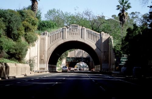
Figueroa Street Bridge Key Facts
| Detail | Information |
| Official name | Figueroa Street Viaduct |
| Location | Over the Los Angeles River, the railroad tracks and San Fernando Road, between Elysian Park and Cypress Park, northeast of downtown Los Angeles, California |
| Coordinates | Approx. 34.0800° N, 118.2270° W |
| Highway today | State Route 110 (Arroyo Seco Parkway), northbound |
| Bridge type | Steel plate girder viaduct |
| Designers | Bridge engineers of the City of Los Angeles and the State of California, working jointly |
| Funding | Federal Bureau of Public Roads (a New Deal-era project) |
| Opened | July 6, 1937 |
| Center span | About 200 ft over the Los Angeles River |
| Distinction | Its river span was one of the longest plate girder spans in the United States when built |
| Construction detail | Double web plates with a filler plate between them in the main girders |
| Companion structures | Figueroa Street Tunnels (1931–1935) to the south; a parallel southbound river bridge added in 1943 |
| Documentation | Recorded by the Historic American Engineering Record as part of the Arroyo Seco Parkway |
| Pedestrians and cyclists | Not permitted (freeway) |
| Toll | None |
| Time zone | Pacific Time: UTC−8 (PST), UTC−7 (PDT, second Sunday in March to first Sunday in November) |
Where the Bridge Is
The Figueroa Street Viaduct crosses the Los Angeles River on the north side of Elysian Park, close to where the Arroyo Seco flows into the river. On its south end, it connects with the Figueroa Street Tunnels, four short tunnels carved through the Elysian Park hills. On its north end, it reaches the Cypress Park and Highland Park area, where the parkway continues northeast toward South Pasadena and Pasadena.
The viaduct crosses several obstacles at once: the Los Angeles River, the busy railroad tracks along its bank and San Fernando Road. Today it carries northbound traffic on the historic Arroyo Seco Parkway (SR 110), one of the most scenic and historic stretches of highway in Southern California.
This bridge is different from the older Riverside–Figueroa Bridge (also called the Dayton Avenue Bridge), a nearby crossing that was replaced by a new Riverside Drive bridge in 2017.
The Engineering
The Figueroa Street Viaduct is a steel plate girder bridge. Its roadway rests on deep steel beams made of welded or riveted plates, rather than on arches or trusses.
- The center span over the Los Angeles River is about 200 feet long. In the 1930s, that made it one of the longest plate girder spans in the country.
- To give the main girders extra strength, engineers used double web plates with a filler plate sandwiched between them.
- The plans were prepared jointly by bridge engineers from the City of Los Angeles and the State of California.
- The project also built about 850 feet of roadway embankment and pavement to connect with Figueroa Street at Avenue 22 north of the river, along with retaining walls and slope paving along the Arroyo Seco.
No Toll to Cross
There’s no toll on the Figueroa Street Viaduct. Because it’s now part of the Arroyo Seco Parkway, it’s a freeway crossing for motor vehicles only. Tips for drivers:
- The Arroyo Seco Parkway was built in an earlier era, with short on-ramps, tight curves and no shoulders in many places. Drive carefully and keep to the posted speed limit.
- Large trucks are restricted on the parkway, so the route mostly carries cars.
- Walkers and cyclists can enjoy views of the river nearby on the Los Angeles River Greenway and at Confluence Park.
Extending Figueroa Street
For years, Los Angeles needed another major route north from downtown to relieve heavy traffic on North Broadway. Figueroa Street, one of the city’s main north–south streets, was the logical choice, but the hills of Elysian Park and the Los Angeles River stood in the way.
The city solved the first problem with the Figueroa Street Tunnels, four tunnels through the Elysian Park hills built between 1931 and 1935. The last barrier was the river and the railroad tracks along it. With funding from the federal Bureau of Public Roads, city and state engineers designed the Figueroa Street Viaduct to carry the extended street across.
The viaduct officially opened on July 6, 1937. Together with the tunnels, it created a direct, high-capacity route between downtown Los Angeles and the northeast side of the city.
Part of the First Freeway in the West
Soon after the viaduct opened, it became part of something even bigger. The Arroyo Seco Parkway opened in 1940 between downtown Los Angeles and Pasadena as the first freeway in the western United States. The Figueroa Street Viaduct and tunnels became part of the parkway’s route.
As traffic grew, a new southbound bridge over the Los Angeles River was added in 1943, just west of the original viaduct. Since then, the 1937 viaduct has carried northbound traffic, and the newer bridge carries southbound traffic.
The Arroyo Seco Parkway is now celebrated as a historic and scenic route. Its bridges, including the Figueroa Street Viaduct, have been documented by the Historic American Engineering Record.
Things to Do Nearby
- Elysian Park, Los Angeles’ oldest park, offers hiking trails and city views next to the tunnels.
- Dodger Stadium, inside Elysian Park, is home to the Los Angeles Dodgers.
- Confluence Park and the Los Angeles River Greenway, near where the Arroyo Seco meets the river, offer walking and biking paths.
- Highland Park, a short drive north, is known for its historic Craftsman homes, cafés and shops along York Boulevard and Figueroa Street.
- The Lummis Home (El Alisal) in Highland Park preserves the stone house of writer and historian Charles Lummis.
FAQs
Q1. Is there a toll on the Figueroa Street Bridge?
A. No. The Figueroa Street Viaduct is free to cross.
Q2. When did the Figueroa Street Viaduct open?
A. It officially opened on July 6, 1937.
Q3. How long is the Figueroa Street Viaduct’s main span?
A. Its center span over the Los Angeles River is about 200 feet.
Q4. What type of bridge is the Figueroa Street Viaduct?
A. It’s a steel plate girder viaduct.
Q5. What highway uses the Figueroa Street Viaduct today?
A. It carries northbound traffic on State Route 110, the Arroyo Seco Parkway.
Q6. Why was the Figueroa Street Viaduct built?
A. It was built to extend Figueroa Street north across the Los Angeles River and railroad tracks, relieving traffic on North Broadway.
Q7. Is the Figueroa Street Viaduct connected to the Figueroa Street Tunnels?
A. Yes. The tunnels through Elysian Park and the viaduct together created the route north from downtown.
Q8. Can you walk across the Figueroa Street Viaduct?
A. No. It’s part of a freeway and is open only to motor vehicles.
Q9. Is this the same as the Riverside–Figueroa Bridge?
A. No. The Riverside–Figueroa Bridge was a separate nearby crossing, replaced by a new Riverside Drive bridge in 2017.
Q10. Who funded the Figueroa Street Viaduct?
A. It was funded through the federal Bureau of Public Roads as part of a 1930s public works program.




Post Comment