Queensboro Bridge, New York, NY: Location, Length, Height, Toll, History & Facts
Queensboro Bridge is the only one of the four great East River bridges that doesn’t hang from cables. Instead of a suspension design, it’s a steel cantilever bridge: a double-decked chain of latticed trusses that crosses from East 59th Street in Manhattan, over Roosevelt Island, to Long Island City in Queens. It opened to the public on March 30, 1909. Most New Yorkers call it the 59th Street Bridge, and in 2011 it was officially renamed the Ed Koch Queensboro Bridge. On an average day it carries close to 130,000 vehicles, which makes it the busiest of the city’s East River bridges for cars.
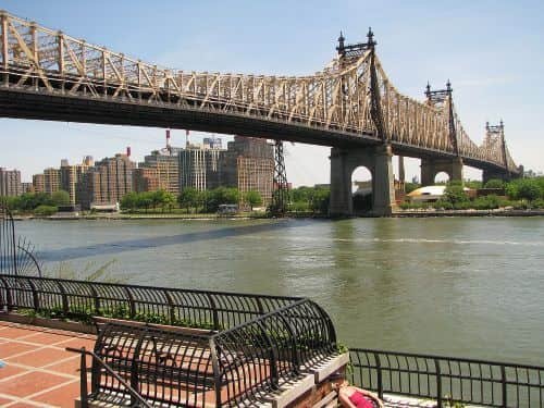
Queensboro Bridge Key Facts
| Detail | Information |
| Official name | Ed Koch Queensboro Bridge (since March 23, 2011) |
| Other names | 59th Street Bridge; originally Blackwell’s Island Bridge |
| Location | East River, between Midtown East, Manhattan and Long Island City, Queens, crossing Roosevelt Island |
| Coordinates | Approx. 40.7568° N, 73.9544° W |
| Manhattan end | East 59th and 60th Streets, between First and Second Avenues |
| Queens end | Queens Plaza, Long Island City |
| Bridge type | Double-decked cantilever truss bridge (five spans) |
| Engineer | Gustav Lindenthal |
| Architect | Henry Hornbostel |
| Construction | 1901–1909 |
| Opened | March 30, 1909 (formal celebration in June 1909) |
| Original cost | About $18 million |
| Operator | New York City Department of Transportation (NYC DOT) |
| Total length (with approaches) | 7,449 ft (2,270 m) |
| Length between anchorages | 3,724.5 ft (1,135 m) |
| Longest span | 1,182 ft (360 m), Manhattan to Roosevelt Island |
| Other spans | 984 ft (Roosevelt Island to Queens); 630 ft (over Roosevelt Island); side spans of 469 ft and 459 ft |
| Width | 100 ft (30 m) |
| Tower height | About 350 ft (107 m) above mean high water |
| Clearance | About 130 ft (40 m) above mean high water |
| Decks | 2 |
| Pedestrian path | South outer roadway, pedestrians only (since May 2025) |
| Bike path | North outer roadway, bikes only (since May 2025) |
| Average daily traffic | 129,874 vehicles; 7,568 cyclists; 2,785 pedestrians |
| Bridge toll | None |
| Congestion Relief Zone charge | Applies to most Manhattan-bound trips that enter at or below 60th Street ($9 peak for cars with E-ZPass) |
| Nearest subway (Manhattan) | Lexington Av/59 St (4, 5, 6, N, R, W) |
| Nearest subway (Queens) | Queensboro Plaza (7, N, W) |
| Time zone | Eastern Time: UTC−5 (EST), UTC−4 (EDT, second Sunday in March to first Sunday in November) |
Midtown to Queens Plaza, With an Island in Between
The Manhattan end lands on East 59th and 60th Streets, a short walk from Bloomingdale’s and the Lexington Avenue subway. From there the bridge rises over the western channel of the East River. It then passes above Roosevelt Island, a narrow island two miles long, and crosses the eastern channel before coming down at Queens Plaza in Long Island City.
Roosevelt Island is the reason the bridge looks the way it does. Instead of stretching one huge span across the full width of the river, the engineers used the island as a stepping stone and planted towers on it. That produced five spans in a row, and the island in the middle meant the bridge didn’t need tall suspension towers.
Next to the bridge on the Manhattan side, the Roosevelt Island Tram glides up alongside the roadway. It’s one of the best free-to-cheap views in the city, since a tram ride costs the same as a subway fare.
How the Spans Add Up
With the approach ramps on both sides included, the bridge is 7,449 feet long, a little over 1.4 miles. Between its two anchorages it measures 3,724.5 feet, broken into five sections:
- The Manhattan side span, 469 feet.
- The main west span, 1,182 feet, from Manhattan to Roosevelt Island.
- The island span, 630 feet.
- The main east span, 984 feet, from Roosevelt Island to Queens.
- The Queens side span, 459 feet.
When it opened, the 1,182-foot span was the longest cantilever span in North America. It kept that title until the Quebec Bridge opened in 1917, and it remained the longest in the United States until 1930. The bridge’s steel towers rise about 350 feet above the water, and the deck gives ships roughly 130 feet of clearance. At 100 feet wide, it carries two full decks of traffic.
Why Cantilever and Not Suspension
At the turn of the 20th century, the Brooklyn and Williamsburg bridges showed that suspension designs worked well over the East River. The Queensboro site was different, because it had an island to stand on. Gustav Lindenthal, the city’s Commissioner of Bridges, saw that towers on Roosevelt Island made a cantilever design possible. It could carry heavy rail and trolley loads without the long approaches and deep anchorages a suspension bridge needs.
In a cantilever bridge, each span extends outward from its towers like two diving boards reaching toward each other. The Queensboro was engineered to carry its own weight through pure cantilever action while handling moving traffic loads as a continuous structure. That required some of the most advanced structural analysis of its day, and a panel of leading engineers reviewed the final design before it was built. The result is the bridge’s signature look: a dense crisscross of steel lattice that rises above the road into peaked towers.
Architect Henry Hornbostel added the decorative touches: the steel finials on the towers, the ornamental railings, and the Beaux-Arts styling that makes the ironwork feel almost lacy from a distance.
The Bridge Crossing Is Free, but Watch the 60th Street Line
The city doesn’t charge a toll on the bridge itself, in either direction. What drivers need to know about is Manhattan’s Congestion Relief Zone, which began in January 2025 and covers streets at and below 60th Street. The bridge lands right on that line, so for drivers the charge depends on which roadway they use:
- Drivers coming from Queens on the lower level exit into the zone and are charged. The peak rate for cars with E-ZPass is $9, from 5 am to 9 pm on weekdays and 9 am to 9 pm on weekends.
- Drivers on the upper level coming from Queens exit north of the zone at 62nd Street, so they can reach the Upper East Side without the charge.
- The overnight rate is 75 percent lower, and a car is charged at most once a day.
- Driving from Manhattan to Queens usually means entering the zone on the way to the bridge, so plan for the charge in both directions unless you start from the zone already.
- The MTA’s phase-in schedule raises the peak charge to $12 in 2028 and $15 in 2031.
Building It, 1901 to 1909
Work on the foundations started in 1901. The original plan was to connect Manhattan with Queens, which had become part of New York City in 1898 and was growing quickly. The bridge was first named Blackwell’s Island Bridge, after the island’s old name, before it became the Queensboro.
The bridge used tens of thousands of tons of steel, and its crews included workers from many immigrant communities, including Irish, Polish, Italian and German laborers from Astoria’s Steinway neighborhood. It opened to the public on March 30, 1909. An official celebration followed in June, with parades, fireworks and a flotilla on the river.
From the start the bridge carried everything: horse carts, early cars, pedestrians, elevated trains and trolleys. One trolley line even stopped in the middle of the bridge, where passengers took an elevator down to Roosevelt Island. That elevator was the island’s only road link until the Roosevelt Island Bridge opened in 1955, and the trolley kept running until 1957.
A Bridge That Keeps Being Renewed
NYC DOT has rebuilt much of the Queensboro in stages, keeping it open to traffic throughout. The most recent project replaced the upper deck. In May 2025, the city reorganized the outer roadways. The north outer roadway, which walkers and cyclists had squeezed onto together for years, became bike-only, and the south outer roadway became a dedicated pedestrian path. That doubled the space for people on foot or on bikes, which matters because the Queensboro is now one of the busiest cycling routes in New York, with more than two million bike trips logged in 2024.
Walking and Cycling Across
The crossing takes about 25 to 35 minutes on foot and roughly 10 minutes by bike.
- Pedestrians use the south outer roadway, which has views downriver toward the Midtown skyline, the United Nations and the Chrysler Building.
- Cyclists use the north outer roadway, which looks upriver toward Roosevelt Island’s lighthouse and the RFK Bridge.
- Both paths connect to protected bike lanes and sidewalks in Long Island City and along Queens Boulevard.
- Sunset from the Queens side is especially good, when the lattice steelwork is lit up against a glowing Manhattan skyline.
- Roosevelt Island has no access from the bridge path, so take the tram or the F train to get there.
Fame Beyond Engineering
The bridge has a strong place in American culture. In The Great Gatsby, F. Scott Fitzgerald describes the view of Manhattan from the Queensboro as something like a first glimpse of the city’s promise. Simon & Garfunkel’s 1966 song “The 59th Street Bridge Song (Feelin’ Groovy)” made the nickname famous around the world. Beneath the Manhattan approach, the vaulted ceilings designed by the Guastavino company form a tiled market hall, known as Bridgemarket, that is still used for shops today.
FAQs
Q1. Is there a toll on the Queensboro Bridge?
No. The bridge itself is free, but most drivers entering Manhattan at or below 60th Street pay the Congestion Relief Zone charge.
Q2. How long is the Queensboro Bridge?
It’s 7,449 feet long including approaches, and 3,724.5 feet between its anchorages.
Q3. How tall is the Queensboro Bridge?
Its towers rise about 350 feet above the water, and the deck clears the river by about 130 feet.
Q4. When did the Queensboro Bridge open?
It opened to the public on March 30, 1909, and was formally celebrated that June.
Q5. Why is it called the 59th Street Bridge?
Its Manhattan end lands at East 59th Street, which is where the popular nickname comes from.
Q6. Who designed the Queensboro Bridge?
Engineer Gustav Lindenthal designed it, and architect Henry Hornbostel created its decorative features.
Q7. Is the Queensboro Bridge a suspension bridge?
No. It’s a cantilever truss bridge, the only one of the four great East River bridges that isn’t a suspension bridge.
Q8. Can you walk across the Queensboro Bridge?
Yes. Pedestrians have their own path on the south outer roadway, and cyclists use the north outer roadway.
Q9. Can you get to Roosevelt Island from the Queensboro Bridge?
Not directly. Take the Roosevelt Island Tram from Manhattan, the F train, or the Roosevelt Island Bridge from Queens.
Q10. When was the Queensboro Bridge renamed after Ed Koch?
It was officially renamed the Ed Koch Queensboro Bridge on March 23, 2011.






Post Comment