Mackinac Bridge, Mackinaw City, MI: Location, Length, Height, Toll, History & Facts
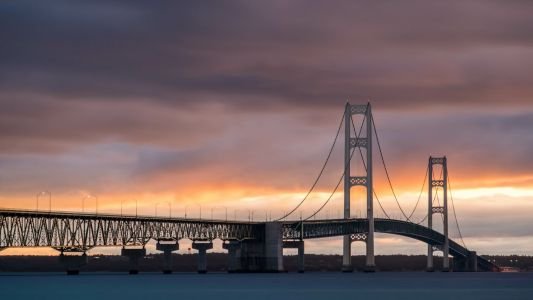
Mackinac Bridge is pronounced “MACK-in-aw,” just like the town at its southern end. It’s the first thing locals will correct if you say it wrong. The bridge stretches five miles across the Straits of Mackinac, where Lake Michigan meets Lake Huron, and connects Mackinaw City in Michigan’s Lower Peninsula with St. Ignace in the Upper Peninsula. It opened on November 1, 1957. Measured between its anchorages, it’s still the longest suspension bridge in the Western Hemisphere, and Michiganders affectionately call it “Mighty Mac.” For most of the year, a car pays just $4 to cross.
Mackinac Bridge Fast Facts
| Detail | Information |
| Location | Straits of Mackinac, between Mackinaw City (Lower Peninsula) and St. Ignace (Upper Peninsula), Michigan, USA |
| Coordinates | Approx. 45.8171° N, 84.7278° W |
| Waters crossed | Straits of Mackinac, linking Lake Michigan and Lake Huron |
| Highway | Interstate 75 |
| Bridge type | Suspension bridge |
| Designer | David B. Steinman |
| Operator | Mackinac Bridge Authority |
| Construction began | May 7, 1954 |
| Opened to traffic | November 1, 1957 |
| Formal dedication | June 28, 1958 |
| Original cost | About $99.8 million |
| Total length (shoreline to shoreline) | 26,372 ft (about 5 miles / 8 km) |
| Length between anchorages | 8,614 ft (2,626 m) |
| Main span | 3,800 ft (1,158 m) |
| Tower height above water | 552 ft (168 m) |
| Tower depth below water | 210 ft (64 m) |
| Roadway height at midspan | About 199 ft (61 m) above water |
| Main cables | 2, each 24¼ in (62 cm) in diameter |
| Total cable wire | About 42,000 miles |
| Deck movement in high winds | Up to 35 ft east or west at midspan |
| Traffic lanes | 4 (2 in each direction) |
| Toll, passenger vehicle | $4.00 ($2.00 per axle) |
| Toll, other vehicles | $5.00 per axle |
| Payment | Cash, credit/debit card (2.3% fee), Apple Pay, Google Pay, MacPass |
| MacPass round trip | Return trip free if completed within 36 hours (passenger vehicles) |
| Walking/cycling | Not allowed, except on the annual Labor Day Bridge Walk |
| Nickname | Mighty Mac |
| Time zone | Eastern Time: UTC−5 (EST), UTC−4 (EDT, second Sunday in March to first Sunday in November) |
Linking Michigan’s Two Peninsulas
Michigan is split into two land masses. The Lower Peninsula, shaped like a mitten, holds Detroit, Grand Rapids and most of the state’s population. The Upper Peninsula to the north is mostly forest, lakeshore and small towns. The Straits of Mackinac separate them, and until 1957 the only way to cross with a car was by ferry.
The bridge carries I-75 straight across the straits. On the south end, Mackinaw City is packed with fudge shops, the reconstructed Colonial Michilimackinac fort, and the docks for ferries to Mackinac Island. On the north end, St. Ignace is the gateway to the Upper Peninsula, with routes west toward Wisconsin and north toward Sault Ste. Marie and Canada. Mackinac Island, where cars have been banned for more than a century, sits a few miles east of the bridge and can be seen from the deck on clear days.
Five Miles, Measured Several Ways
People measure the Mackinac Bridge in a few different ways, and each number tells you something:
- Shoreline to shoreline, the total length is 26,372 feet, just under five miles. At the posted speed limit, the crossing takes about 10 minutes.
- Between the two cable anchorages, the suspended length is 8,614 feet. That’s the measurement that makes it the longest suspension bridge in the Western Hemisphere.
- The main span, between the two towers, is 3,800 feet.
The towers rise 552 feet above the water, and they reach another 210 feet below the surface to bedrock. At midspan, the roadway is about 199 feet above the straits, high enough for the large freighters that carry iron ore and grain across the Great Lakes.
Steinman designed the deck to move. In very strong winds, the center of the bridge can swing as much as 35 feet east or west. That flexibility is intentional, and it’s a big part of why the bridge has stood up to decades of Great Lakes storms.
What the Toll Costs
The toll plaza is at the St. Ignace end, and drivers pay in both directions.
| Vehicle | Toll |
| Passenger vehicles (car, van, SUV, pickup, motorcycle) | $4.00 ($2.00 per axle) |
| Other vehicles (trucks, buses, motor homes) | $5.00 per axle |
Tips for drivers:
- Cash, credit and debit cards, Apple Pay and Google Pay are all accepted. Card payments carry a 2.3 percent fee, so cash is slightly cheaper.
- MacPass is the bridge’s own prepaid account. It uses a windshield sticker so you can drive through designated lanes without stopping.
- The best deal is MacPass’s commuter discount. If a passenger vehicle makes a round trip within 36 hours, the return crossing is free, so the round trip costs $4 instead of $8.
- E-ZPass, I-Pass and other toll tags aren’t accepted here. MacPass is the only transponder the bridge uses.
- If you’re towing a trailer, it’s charged per axle at the lead vehicle’s rate. The exception is a car towed behind a motor home, which pays the car rate.
The Man Who Believed It Could Be Built
People dreamed of a bridge across the straits as early as the 1880s. A St. Ignace merchant even printed an ad showing a drawing of the Brooklyn Bridge with the caption “Proposed bridge across the Straits of Mackinac.” For decades, skeptics said the straits were too wide, too deep, too icy and too windy.
The state created a bridge authority in 1934, but the Depression and World War II held things up. Things finally moved in the early 1950s, when the Mackinac Bridge Authority hired David B. Steinman, one of America’s leading bridge engineers. Steinman had studied the 1940 failure of the Tacoma Narrows Bridge closely. He designed the Mackinac deck with a deep stiffening truss and open steel grating in the center lanes, which lets wind pass through instead of pushing against a solid surface.
Construction began on May 7, 1954. Thousands of workers took part, and crews worked through the short northern seasons to sink the foundations, raise the towers and spin the cables. The bridge opened to traffic on November 1, 1957, and was formally dedicated on June 28, 1958. The ferries that had carried cars across the straits were retired soon after.
Walking Mighty Mac on Labor Day
The bridge doesn’t have a sidewalk, and walking or biking across is prohibited on normal days. Once a year, though, on Labor Day morning, thousands of people walk from St. Ignace to Mackinaw City in the Mackinac Bridge Walk. The tradition began with the bridge’s formal dedication in 1958, and the Governor of Michigan traditionally leads the walk.
- The walk covers the full five miles and takes most people about one and a half to two hours.
- Participants usually start on the St. Ignace side and finish in Mackinaw City, with shuttle buses available to bring them back.
- Check the Mackinac Bridge Authority’s website for the current year’s start times, rules and lane setup.
For Nervous Drivers
The height, the wind and the long open grating in the inner lanes make some people uneasy. The Mackinac Bridge Authority offers a free Drivers Assistance Program. Call ahead or ask at the toll plaza, and an authority employee will drive your car across for you while you ride along. It’s used year-round by drivers who don’t want to take the wheel over the straits.
Other advice for a smoother crossing:
- Stay in the outer lanes if the open grating in the inner lanes bothers you. The outer lanes have a solid deck surface.
- Pay attention to the wind advisories posted at the approaches. In very high winds, the authority may restrict high-profile vehicles or escort them across.
- Keep a safe following distance and stay in your lane. Lane changes on the bridge are discouraged.
Colors, Lights and Details
- The towers are painted ivory, and the cables and suspended span are painted “foliage green.” Keeping the bridge painted is an ongoing job for the authority’s crews.
- At night, lights along the cables outline the bridge’s shape, and it glows over the straits.
- The best views are from Bridge View Park in St. Ignace and from the waterfront parks in Mackinaw City, especially at sunset.
- The Mackinac Bridge Museum in Mackinaw City displays tools, photos and stories from the construction years.
- Since the bridge opened, more than 200 million vehicles have crossed it. Summer weekends are the busiest time, when tourists head north to the Upper Peninsula.
FAQs
Q1. How much is the Mackinac Bridge toll?
Passenger vehicles pay $4.00 ($2.00 per axle), and other vehicles such as trucks and motor homes pay $5.00 per axle.
Q2. Do you pay the Mackinac Bridge toll both ways?
Yes, but MacPass holders get the return trip free if they complete a round trip within 36 hours.
Q3. How long is the Mackinac Bridge?
It’s 26,372 feet, about five miles, from shore to shore. The suspended section between the anchorages is 8,614 feet.
Q4. How tall is the Mackinac Bridge?
The towers rise 552 feet above the water, and the roadway is about 199 feet above the straits at midspan.
Q5. When was the Mackinac Bridge built?
Construction began on May 7, 1954, and the bridge opened to traffic on November 1, 1957.
Q6. Who designed the Mackinac Bridge?
It was designed by engineer David B. Steinman.
Q7. How do you pronounce Mackinac?
It’s pronounced “MACK-in-aw,” the same as Mackinaw City.
Q8. Can you walk across the Mackinac Bridge?
Only on Labor Day morning, during the annual Mackinac Bridge Walk. Walking and biking aren’t allowed the rest of the year.
Q9. Does the Mackinac Bridge accept E-ZPass?
No. The bridge accepts only cash, cards, Apple Pay, Google Pay and its own MacPass.
Q10. What if I’m afraid to drive across the Mackinac Bridge?
You can use the free Drivers Assistance Program, where a bridge authority employee drives your car across for you.






Post Comment