Glen Canyon Bridge, Page, AZ: Location, Length, Height, Toll, History & Facts
Glen Canyon Bridge was built so that a dam could be built. In the 1950s, the site of Glen Canyon Dam was one of the most remote places in the United States, with no railroad and no easy way to bring in millions of tons of materials. So the U.S. Bureau of Reclamation first threw a single steel arch across the canyon, 700 feet above the Colorado River. When it was completed in 1959, it was the highest arch bridge in the world. Today it carries US Highway 89 just downstream from Glen Canyon Dam, near Page, Arizona, and its sidewalk offers some of the most breathtaking views in the Southwest. It’s free to cross.
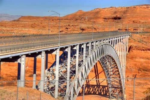
Glen Canyon Bridge Key Facts
| Detail | Information |
| Other name | Glen Canyon Dam Bridge |
| Location | Colorado River, about 865 ft downstream of Glen Canyon Dam, near Page, Coconino County, Arizona |
| Coordinates | Approx. 36.9356° N, 111.4834° W |
| Highway | US Route 89 |
| Designer | U.S. Bureau of Reclamation |
| Builder | Kiewit–Judson Pacific Murphy joint venture |
| Bridge type | Single-span steel open-spandrel arch |
| Construction | February 1957 to early 1959 |
| Construction cost | About $4 million |
| Total length | 1,271 ft (387 m) |
| Main arch span | 1,028 ft (313 m) |
| Height of deck above the river | About 700 ft (213 m) |
| Lanes | 2 |
| Sidewalk | Yes, a level, accessible sidewalk with guardrails |
| World record | Highest arch bridge in the world when completed (1959) |
| US ranking | Second-longest steel arch bridge in the US when completed; still one of the highest bridges in the country |
| Nearby | Carl Hayden Visitor Center (west end) and Glen Canyon Dam |
| Toll | None |
| Time zone | Arizona time, Mountain Standard Time all year (UTC−7) |
Beside Glen Canyon Dam
The Glen Canyon Bridge crosses the Colorado River about two miles north of downtown Page, Arizona, in Glen Canyon National Recreation Area. It sits just 865 feet downstream from Glen Canyon Dam, the 710-foot concrete dam that holds back Lake Powell, one of the largest reservoirs in the country.
From the bridge, visitors can look upstream at the massive curved face of the dam, and downstream at the emerald-green Colorado River winding between towering red sandstone walls toward Lees Ferry and the Grand Canyon. The Carl Hayden Visitor Center stands at the bridge’s west end, perched on the canyon rim.
A Single Steel Arch
The Glen Canyon Bridge is a single-span steel open-spandrel arch. A huge steel arch springs from the canyon walls, and steel columns rising from the arch support the roadway.
- The bridge is 1,271 feet long overall.
- Its main arch spans 1,028 feet from one canyon wall to the other.
- The deck stands about 700 feet above the river, roughly the height of a 70-story building.
- It carries two lanes of US 89, plus a sidewalk with guardrails.
When it was completed, it was the highest arch bridge in the world and the second-longest steel arch bridge in the United States.
Free to Cross
There’s no toll on the Glen Canyon Bridge. Tips for visiting:
- Drivers cross on US 89, the main highway between Flagstaff, Page and Kanab, Utah.
- Walkers can stroll the sidewalk for spectacular views of the dam and canyon. It’s level and accessible.
- Parking is free at the Carl Hayden Visitor Center on the west side of the bridge.
- Pets on leashes may use the sidewalk.
- Bring water and sun protection, especially in summer.
- Arizona time: Page stays on Mountain Standard Time all year, since most of Arizona doesn’t observe daylight saving time.
Building a Bridge for a Dam
In the mid-1950s, the federal government launched the Colorado River Storage Project, with Glen Canyon Dam as its centerpiece. But the dam site was deep in a remote canyon, with the nearest railroad far away. Getting heavy equipment, steel and cement to the dam would have meant a long trip around the canyon.
The Bureau of Reclamation decided to build a bridge first. Construction began in February 1957. Because the canyon was about 700 feet deep, it was impossible to build temporary falsework supports from the river up. Instead, crews used two cableways stretched across the canyon:
- A smaller cableway, with a 12-ton capacity, carried workers and small supplies.
- A larger cableway, with a 25-ton capacity, hauled the heavy steel bridge members.
The two halves of the arch were built outward from each canyon wall, held in place by tie-back cables anchored into the rock until they met in the middle. Using tie-back cables to swing the span into its final position, and the method used to tension them, were new to bridge building at the time.
The bridge was completed in early 1959, at a cost of about $4 million. Once it opened, trucks could bring materials straight to the dam site, and work on Glen Canyon Dam continued until 1966.
Rerouting US 89 and the Birth of Page
When the bridge was finished, the main route of US Highway 89 was moved onto it. The old route, which crossed the Colorado River at Navajo Bridge in Marble Canyon, became US 89A.
The town of Page itself grew out of the dam project. It was founded in 1957 as a camp for the workers building Glen Canyon Dam and was named for John C. Page, a former commissioner of the Bureau of Reclamation. Today Page is a gateway to Lake Powell, Horseshoe Bend, Antelope Canyon and other Southwest wonders.
Carl Hayden Visitor Center
Right beside the bridge, the Carl Hayden Visitor Center is named for the longtime Arizona senator. It has exhibits about the history of Glen Canyon and the building of the dam and bridge, plus large windows looking out over the dam and Lake Powell. It typically opens daily, with longer hours in summer, and offers tours of Glen Canyon Dam. Check current hours and tour availability before your visit.
Things to Do Nearby
- Glen Canyon Dam tours start from the Carl Hayden Visitor Center and take visitors inside the dam.
- Lake Powell, upstream of the dam, is famous for houseboating, kayaking and its red-rock coves.
- Horseshoe Bend, a few miles south, offers one of the most photographed views of the Colorado River.
- Antelope Canyon, on Navajo land near Page, is known for its glowing slot canyon walls, visited on guided tours.
- Lees Ferry and Navajo Bridge, downstream, mark the start of the Grand Canyon.
FAQs
Q1. Is there a toll on the Glen Canyon Bridge?
A. No. The Glen Canyon Bridge is free to cross.
Q2. How long is the Glen Canyon Bridge?
A. It’s 1,271 feet long, with a main arch span of 1,028 feet.
Q3. How high is the Glen Canyon Bridge?
A. The deck stands about 700 feet above the Colorado River.
Q4. When was the Glen Canyon Bridge built?
A. Construction began in February 1957, and the bridge was completed in early 1959.
Q5. Was the Glen Canyon Bridge ever the highest bridge in the world?
A. Yes. When completed in 1959, it was the highest arch bridge in the world.
Q6. Why was the Glen Canyon Bridge built?
A. It was built to carry construction materials and equipment to the Glen Canyon Dam site.
Q7. Can you walk across the Glen Canyon Bridge?
A. Yes. A sidewalk with guardrails lets visitors walk across for views of the dam and canyon.
Q8. What highway crosses the Glen Canyon Bridge?
A. US Route 89 crosses the bridge near Page, Arizona.
Q9. How far is the Glen Canyon Bridge from the dam?
A. The bridge is about 865 feet downstream from Glen Canyon Dam.
Q10. Who built the Glen Canyon Bridge?
A. It was designed by the U.S. Bureau of Reclamation and built by the Kiewit–Judson Pacific Murphy joint venture.






Post Comment