Coronado Bridge, San Diego, CA: Location, Length, Height, Toll, History & Facts
Coronado Bridge bends for a reason. When San Diego planned a bridge to Coronado in the 1960s, the U.S. Navy insisted on at least 200 feet of clearance so its tallest ships could pass underneath. Architect Robert Mosher’s answer was a graceful 80-degree curve that let the roadway climb gently while gaining the length it needed to reach that height. The result is one of the most recognizable bridges in California, a 2.1-mile sweep of blue-gray arches over San Diego Bay. It opened on August 3, 1969, during San Diego’s 200th-anniversary celebration, and won an Award of Merit as one of the most beautiful bridges in America. Tolls ended in 2002, so crossing is free.
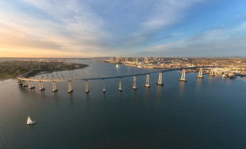
Coronado Bridge Key Facts
| Detail | Information |
| Official name | San Diego–Coronado Bridge |
| Location | San Diego Bay, between Barrio Logan in San Diego and the city of Coronado, California |
| Coordinates | Approx. 32.6865° N, 117.1583° W |
| Highway | State Route 75 (connects with Interstate 5) |
| Operator | California Department of Transportation (Caltrans) |
| Bridge type | Box girder bridge with an orthotropic steel deck over the main spans and prestressed concrete approaches |
| Architect | Robert Mosher (Mosher & Drew) |
| Builder | Murphy-Pacific |
| Construction began | February 1967 |
| Opened | August 3, 1969 |
| Construction cost | About $48–50 million |
| Total length | 11,179 ft (about 2.1 miles), including approaches |
| Main span | 660 ft (200 m) |
| Number of spans | 32 |
| Vertical clearance | About 200 ft |
| Curve | Turns 80 degrees, climbing at a 4.67 percent grade |
| Width | About 63 ft between curbs |
| Lanes | 5, with a movable barrier for a reversible center lane |
| Materials | About 20,000 tons of steel and 94,000 cubic yards of concrete |
| Original toll | 60 cents each way (1969) |
| Tolls ended | June 27, 2002 |
| Award | AISC “Most Beautiful Bridge” Award of Merit (1970) |
| Toll | None |
| Time zone | Pacific Time: UTC−8 (PST), UTC−7 (PDT, second Sunday in March to first Sunday in November) |
Spanning San Diego Bay
The Coronado Bridge crosses San Diego Bay between the mainland and Coronado, a peninsula usually called “Coronado Island.” On the San Diego side, it begins in the Barrio Logan neighborhood, just south of downtown, and connects with Interstate 5. On the Coronado side, it lands near the city’s downtown and becomes State Route 75, leading to Orange Avenue, the Hotel del Coronado and Coronado’s famous beaches.
The bay below is home to Naval Base San Diego and Naval Air Station North Island. Navy ships, cruise ships, sailboats and ferries regularly pass beneath the bridge, and on clear days drivers enjoy wide views of the downtown skyline, Point Loma and the Pacific.
Why the Bridge Curves
The bridge’s famous curve was a creative engineering solution:
- The Navy required at least 200 feet of clearance for the tallest ships operating from its San Diego bases.
- A straight bridge would have needed a very steep climb to reach that height in the distance available.
- By curving the bridge 80 degrees, architect Robert Mosher added length, letting the roadway climb at a steady 4.67 percent grade.
The result is a bridge that’s both practical and beautiful, often described as a work of public art.
Length, Height and Design
- The bridge is 11,179 feet long, about 2.1 miles, including approaches.
- It has 32 spans, with a longest span of 660 feet over the main shipping channel.
- The deck reaches about 200 feet above the bay at its highest point.
- It’s supported by 30 graceful, mission arch-shaped concrete piers, which echo the arched designs of California’s Spanish missions.
- The piers stand on clusters of 54-inch-diameter piles driven up to about 100 feet into the bay floor.
- All braces and stiffeners are hidden inside the box girders, giving the bridge its smooth, sleek look.
- Its railing is only 34 inches high, low enough to give drivers an open view of the bay.
Building the bridge took about 20,000 tons of steel and 94,000 cubic yards of concrete. Mosher also chose the distinctive soft blue color of the piers.
Free to Cross
There’s no toll on the Coronado Bridge today. When it opened in 1969, drivers paid 60 cents in each direction. The tolls were removed on June 27, 2002.
Tips for drivers:
- The bridge has five lanes, with a movable barrier that shifts the center lane to handle rush-hour traffic in the busier direction.
- Pedestrians and cyclists aren’t allowed on the bridge. The Coronado Ferry offers a scenic way to cross the bay instead.
- Traffic can back up during Navy shift changes and on summer weekends when beachgoers head to Coronado.
- The ride over the top gives some of the best views in San Diego. Passengers should have cameras ready.
Building the Bridge
Before the bridge, the only ways to reach Coronado from San Diego were by ferry or by a long drive around the bay along the Silver Strand. Ferries had carried passengers and cars across the bay for decades.
Plans for a bridge took years to come together, largely because of the Navy’s concerns about shipping in the bay. By 1964, the Navy agreed to support a bridge with at least 200 feet of clearance. Construction began in February 1967, and the steel girders were fabricated in the San Francisco Bay Area and brought to San Diego by barge.
The bridge opened on August 3, 1969, as part of San Diego’s 200th-anniversary celebration. In 1970, the American Institute of Steel Construction gave it its “Most Beautiful Bridge” Award of Merit, and the bridge quickly became a beloved San Diego landmark.
Chicano Park: Art Beneath the Bridge
Beneath the San Diego end of the bridge lies Chicano Park, one of the city’s most remarkable cultural sites. Residents of Barrio Logan created the park in 1970, and over the following decades artists painted vibrant murals on the bridge’s concrete pillars and ramps, celebrating Chicano culture, history and community. Today the park holds one of the largest collections of outdoor murals in the United States, and it has been designated a National Historic Landmark.
Things to Do Nearby
- Chicano Park, beneath the bridge in Barrio Logan, showcases world-famous murals painted on the bridge’s pillars.
- The Hotel del Coronado, a historic Victorian beach resort, is a short drive from the bridge’s Coronado end.
- Coronado Beach is regularly ranked among the best beaches in the country.
- The Coronado Ferry Landing offers shops, restaurants and stunning views of the bridge and downtown skyline.
- The USS Midway Museum, on the downtown San Diego waterfront, lets visitors tour a historic aircraft carrier.
FAQs
Q1. Is there a toll on the Coronado Bridge?
A. No. Tolls ended on June 27, 2002, and the bridge is free to cross.
Q2. How long is the Coronado Bridge?
A. It’s 11,179 feet long, about 2.1 miles, including approaches.
Q3. How high is the Coronado Bridge?
A. The deck reaches about 200 feet above San Diego Bay at its highest point.
Q4. When was the Coronado Bridge built?
A. Construction began in February 1967, and the bridge opened on August 3, 1969.
Q5. Why is the Coronado Bridge curved?
A. The curve added length so the roadway could reach the Navy’s required 200-foot clearance at a gentle grade.
Q6. Who designed the Coronado Bridge?
A. It was designed by architect Robert Mosher.
Q7. Can you walk or bike across the Coronado Bridge?
A. No. Pedestrians and cyclists aren’t allowed. The Coronado Ferry is a popular alternative.
Q8. How many lanes does the Coronado Bridge have?
A. It has five lanes, with a movable barrier for a reversible center lane.
Q9. What is under the Coronado Bridge?
A. Chicano Park, with its world-famous murals, lies beneath the bridge’s San Diego end.
Q10. Did the Coronado Bridge win any awards?
A. Yes. In 1970, it won the AISC “Most Beautiful Bridge” Award of Merit.






Post Comment